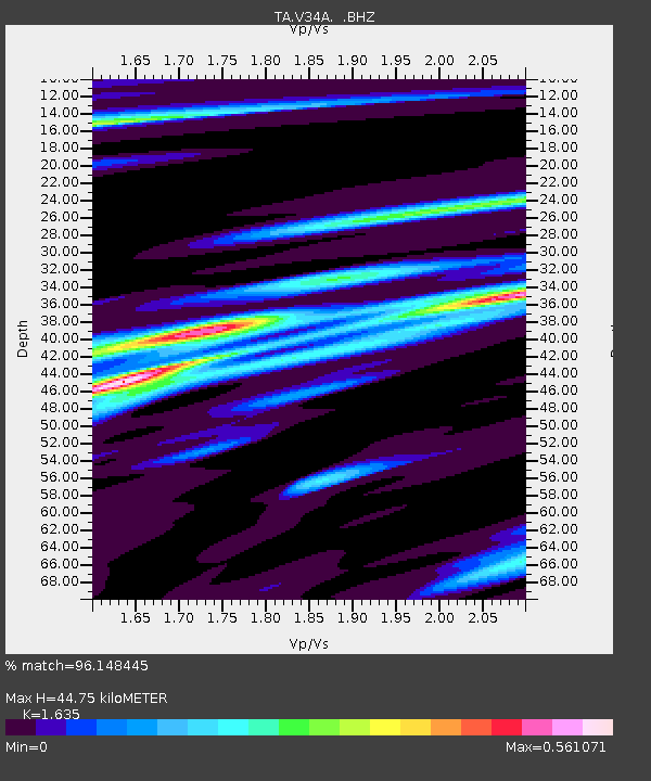
V34A Guthrie, OK, USA - Earthquake Result Viewer

Earthquake location: Off East Coast Of Honshu, Japan
Earthquake latitude/longitude: 38.0/143.3
Earthquake time(UTC): 2011/07/10 (191) 00:57:10 GMT
Earthquake Depth: 23 km
Earthquake Magnitude: 6.6 MB, 7.0 MS, 7.0 MW, 7.0 MW
Earthquake Catalog/Contributor: WHDF/NEIC
Network: TA USArray Transportable Network (new EarthScope stations)
Station: V34A Guthrie, OK, USA
Lat/Lon: 35.83 N/97.52 W
Elevation: 329 m
Distance: 87.5 deg
Az: 45.226 deg
Baz: 316.381 deg
Ray Param: 0.043291684
Estimated Moho Depth: 44.75 km
Estimated Crust Vp/Vs: 1.63
Assumed Crust Vp: 6.426 km/s
Estimated Crust Vs: 3.93 km/s
Estimated Crust Poisson's Ratio: 0.20
Radial Match: 96.148445 %
Radial Bump: 327
Transverse Match: 90.418564 %
Transverse Bump: 400
SOD ConfigId: 395004
Insert Time: 2011-12-16 06:33:20.273 +0000
GWidth: 2.5
Max Bumps: 400
Tol: 0.001

Signal To Noise

ChannelStoNSTALTA
TA:V34A: :BHZ:20110710T01:09:24.875012Z9.0096079.888919E-71.097597E-7
TA:V34A: :BHN:20110710T01:09:24.875012Z2.25052262.3690812E-71.0526805E-7
TA:V34A: :BHE:20110710T01:09:24.875012Z1.51039551.7083865E-71.1310855E-7
Arrivals
Ps4.5 SECOND
PpPs18 SECOND
PsPs/PpSs22 SECOND