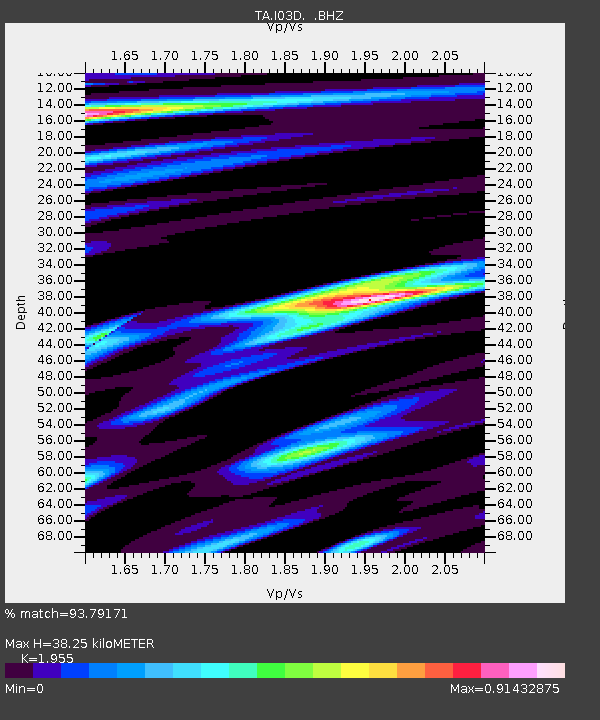
I03D Drain, OR, USA - Earthquake Result Viewer

Earthquake location: Off East Coast Of Honshu, Japan
Earthquake latitude/longitude: 38.0/143.3
Earthquake time(UTC): 2011/07/10 (191) 00:57:10 GMT
Earthquake Depth: 23 km
Earthquake Magnitude: 6.6 MB, 7.0 MS, 7.0 MW, 7.0 MW
Earthquake Catalog/Contributor: WHDF/NEIC
Network: TA USArray Transportable Network (new EarthScope stations)
Station: I03D Drain, OR, USA
Lat/Lon: 43.70 N/123.35 W
Elevation: 140 m
Distance: 67.1 deg
Az: 51.793 deg
Baz: 301.187 deg
Ray Param: 0.057125524
Estimated Moho Depth: 38.25 km
Estimated Crust Vp/Vs: 1.96
Assumed Crust Vp: 6.522 km/s
Estimated Crust Vs: 3.336 km/s
Estimated Crust Poisson's Ratio: 0.32
Radial Match: 93.79171 %
Radial Bump: 400
Transverse Match: 83.229355 %
Transverse Bump: 400
SOD ConfigId: 395004
Insert Time: 2011-12-16 06:33:21.967 +0000
GWidth: 2.5
Max Bumps: 400
Tol: 0.001

Signal To Noise

ChannelStoNSTALTA
TA:I03D: :BHZ:20110710T01:07:31.500012Z8.356231.4950829E-61.7891834E-7
TA:I03D: :BHN:20110710T01:07:31.500012Z1.39961682.977195E-72.1271501E-7
TA:I03D: :BHE:20110710T01:07:31.500012Z3.24393255.5885744E-71.7227777E-7
Arrivals
Ps5.8 SECOND
PpPs17 SECOND
PsPs/PpSs23 SECOND