534A Blanco, TX, USA - Earthquake Result Viewer
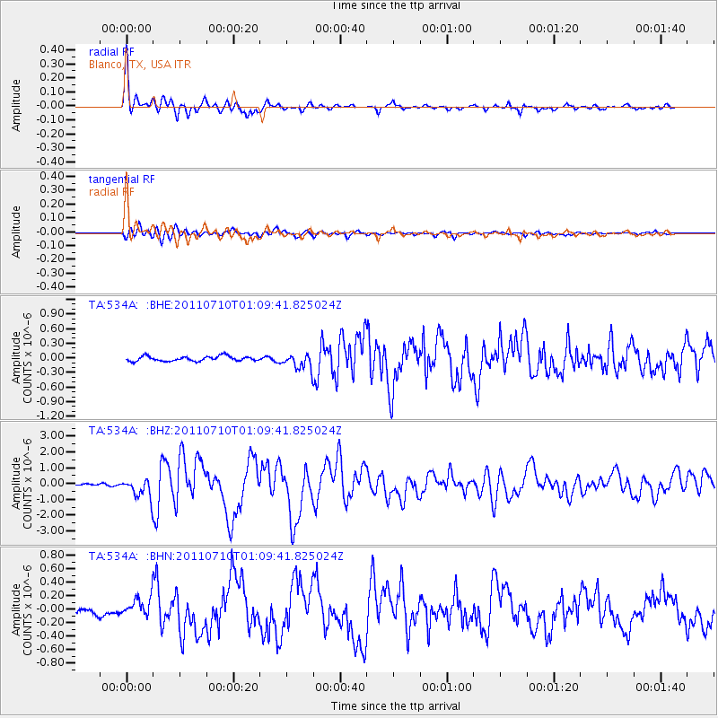
Earthquake location: Off East Coast Of Honshu, Japan
Earthquake latitude/longitude: 38.0/143.3
Earthquake time(UTC): 2011/07/10 (191) 00:57:10 GMT
Earthquake Depth: 23 km
Earthquake Magnitude: 6.6 MB, 7.0 MS, 7.0 MW, 7.0 MW
Earthquake Catalog/Contributor: WHDF/NEIC
Network: TA USArray Transportable Network (new EarthScope stations)
Station: 534A Blanco, TX, USA
Lat/Lon: 30.03 N/98.48 W
Elevation: 461 m
Distance: 91.1 deg
Az: 49.817 deg
Baz: 315.921 deg
Ray Param: 0.041625857
Estimated Moho Depth: 47.0 km
Estimated Crust Vp/Vs: 1.66
Assumed Crust Vp: 6.498 km/s
Estimated Crust Vs: 3.902 km/s
Estimated Crust Poisson's Ratio: 0.22
Radial Match: 96.35662 %
Radial Bump: 354
Transverse Match: 82.29004 %
Transverse Bump: 400
SOD ConfigId: 395004
Insert Time: 2011-12-16 06:33:54.661 +0000
GWidth: 2.5
Max Bumps: 400
Tol: 0.001

Signal To Noise

ChannelStoNSTALTA
TA:534A: :BHZ:20110710T01:09:41.825024Z11.5116416.225824E-75.4082857E-8
TA:534A: :BHN:20110710T01:09:41.825024Z3.09208131.4615033E-74.7266003E-8
TA:534A: :BHE:20110710T01:09:41.825024Z3.25957781.6017272E-74.91391E-8
Arrivals
Ps4.9 SECOND
PpPs19 SECOND
PsPs/PpSs24 SECOND