You are here: Home > Network List > TA - USArray Transportable Network (new EarthScope stations) Stations List
> Station Y33A Hilltop Ranch, Iowa Park, TX, USA > Earthquake Result Viewer
Y33A Hilltop Ranch, Iowa Park, TX, USA - Earthquake Result Viewer

| Earthquake location: |
Off East Coast Of Honshu, Japan |
| Earthquake latitude/longitude: |
38.0/143.3 |
| Earthquake time(UTC): |
2011/07/10 (191) 00:57:10 GMT |
| Earthquake Depth: |
23 km |
| Earthquake Magnitude: |
6.6 MB, 7.0 MS, 7.0 MW, 7.0 MW |
| Earthquake Catalog/Contributor: |
WHDF/NEIC |
|
| Network: |
TA USArray Transportable Network (new EarthScope stations) |
| Station: |
Y33A Hilltop Ranch, Iowa Park, TX, USA |
| Lat/Lon: |
34.01 N/98.63 W |
| Elevation: |
321 m |
|
| Distance: |
88.1 deg |
| Az: |
47.146 deg |
| Baz: |
315.824 deg |
| Ray Param: |
0.04278769 |
| Estimated Moho Depth: |
58.25 km |
| Estimated Crust Vp/Vs: |
1.62 |
| Assumed Crust Vp: |
6.315 km/s |
| Estimated Crust Vs: |
3.886 km/s |
| Estimated Crust Poisson's Ratio: |
0.20 |
|
| Radial Match: |
95.08487 % |
| Radial Bump: |
400 |
| Transverse Match: |
88.01049 % |
| Transverse Bump: |
400 |
| SOD ConfigId: |
395004 |
| Insert Time: |
2011-12-16 06:34:16.455 +0000 |
| GWidth: |
2.5 |
| Max Bumps: |
400 |
| Tol: |
0.001 |
|
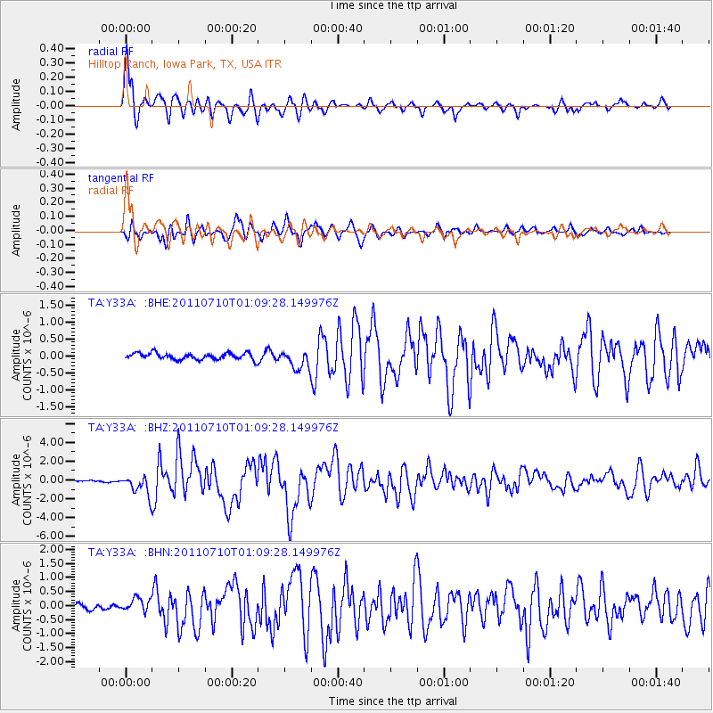
Signal To Noise
| Channel | StoN | STA | LTA |
| TA:Y33A: :BHZ:20110710T01:09:28.149976Z | 13.64874 | 1.0566017E-6 | 7.7413866E-8 |
| TA:Y33A: :BHN:20110710T01:09:28.149976Z | 2.1791904 | 2.407347E-7 | 1.1046979E-7 |
| TA:Y33A: :BHE:20110710T01:09:28.149976Z | 2.9236164 | 2.81961E-7 | 9.644255E-8 |
| Arrivals |
| Ps | 5.9 SECOND |
| PpPs | 24 SECOND |
| PsPs/PpSs | 30 SECOND |


