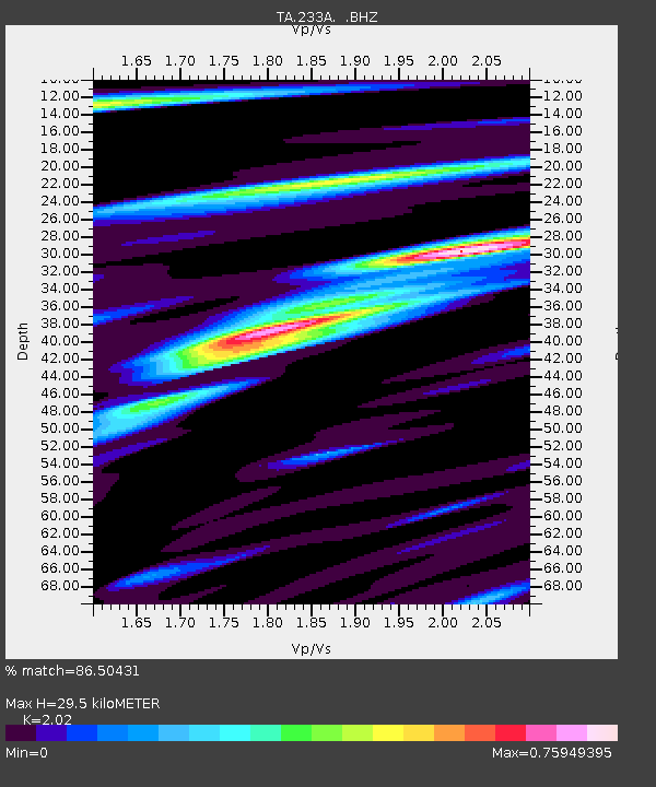
233A Rising Star, TX, USA - Earthquake Result Viewer
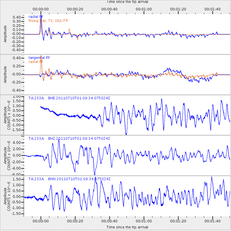
Earthquake location: Off East Coast Of Honshu, Japan
Earthquake latitude/longitude: 38.0/143.3
Earthquake time(UTC): 2011/07/10 (191) 00:57:10 GMT
Earthquake Depth: 23 km
Earthquake Magnitude: 6.6 MB, 7.0 MS, 7.0 MW, 7.0 MW
Earthquake Catalog/Contributor: WHDF/NEIC
Network: TA USArray Transportable Network (new EarthScope stations)
Station: 233A Rising Star, TX, USA
Lat/Lon: 32.02 N/98.90 W
Elevation: 539 m
Distance: 89.4 deg
Az: 48.696 deg
Baz: 315.708 deg
Ray Param: 0.041857243
Estimated Moho Depth: 29.5 km
Estimated Crust Vp/Vs: 2.02
Assumed Crust Vp: 6.426 km/s
Estimated Crust Vs: 3.181 km/s
Estimated Crust Poisson's Ratio: 0.34
Radial Match: 86.50431 %
Radial Bump: 400
Transverse Match: 62.866184 %
Transverse Bump: 400
SOD ConfigId: 395004
Insert Time: 2011-12-16 06:35:42.388 +0000
GWidth: 2.5
Max Bumps: 400
Tol: 0.001

Signal To Noise

ChannelStoNSTALTA
TA:233A: :BHZ:20110710T01:09:34.075024Z7.4765346.827344E-79.131697E-8
TA:233A: :BHN:20110710T01:09:34.075024Z2.1254911.8011191E-78.473897E-8
TA:233A: :BHE:20110710T01:09:34.075024Z1.21157233.8129645E-73.1471208E-7
Arrivals
Ps4.8 SECOND
PpPs14 SECOND
PsPs/PpSs18 SECOND