You are here: Home > Network List > TA - USArray Transportable Network (new EarthScope stations) Stations List
> Station S36A Lake Cedric, Chanute, KS, USA > Earthquake Result Viewer
S36A Lake Cedric, Chanute, KS, USA - Earthquake Result Viewer
| Earthquake location: |
Off East Coast Of Honshu, Japan |
| Earthquake latitude/longitude: |
38.0/143.3 |
| Earthquake time(UTC): |
2011/07/10 (191) 00:57:10 GMT |
| Earthquake Depth: |
23 km |
| Earthquake Magnitude: |
6.6 MB, 7.0 MS, 7.0 MW, 7.0 MW |
| Earthquake Catalog/Contributor: |
WHDF/NEIC |
|
| Network: |
TA USArray Transportable Network (new EarthScope stations) |
| Station: |
S36A Lake Cedric, Chanute, KS, USA |
| Lat/Lon: |
37.72 N/95.59 W |
| Elevation: |
299 m |
|
| Distance: |
87.1 deg |
| Az: |
42.806 deg |
| Baz: |
317.415 deg |
| Ray Param: |
0.043519787 |
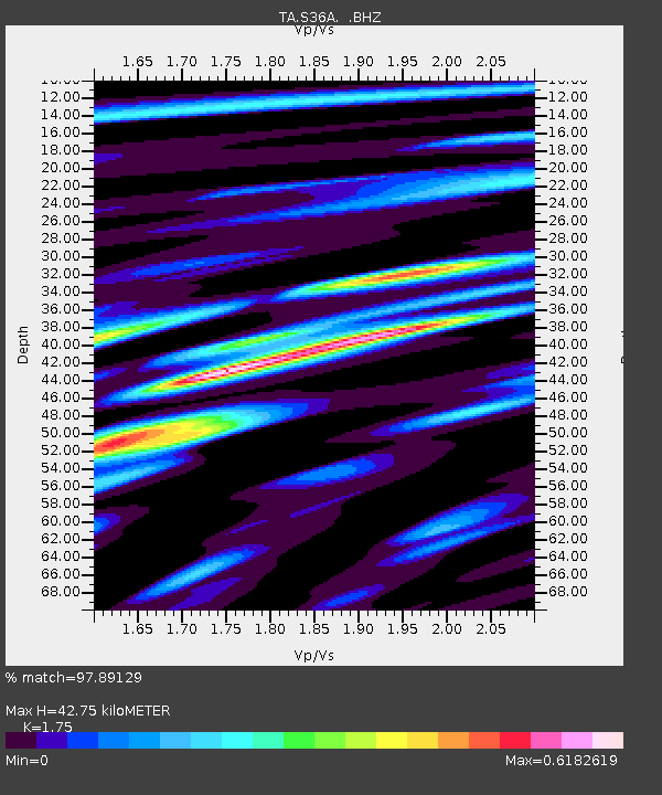
| Estimated Moho Depth: |
42.75 km |
| Estimated Crust Vp/Vs: |
1.75 |
| Assumed Crust Vp: |
6.53 km/s |
| Estimated Crust Vs: |
3.732 km/s |
| Estimated Crust Poisson's Ratio: |
0.26 |
|
| Radial Match: |
97.89129 % |
| Radial Bump: |
298 |
| Transverse Match: |
86.55435 % |
| Transverse Bump: |
400 |
| SOD ConfigId: |
395004 |
| Insert Time: |
2011-12-16 06:39:26.450 +0000 |
| GWidth: |
2.5 |
| Max Bumps: |
400 |
| Tol: |
0.001 |
|
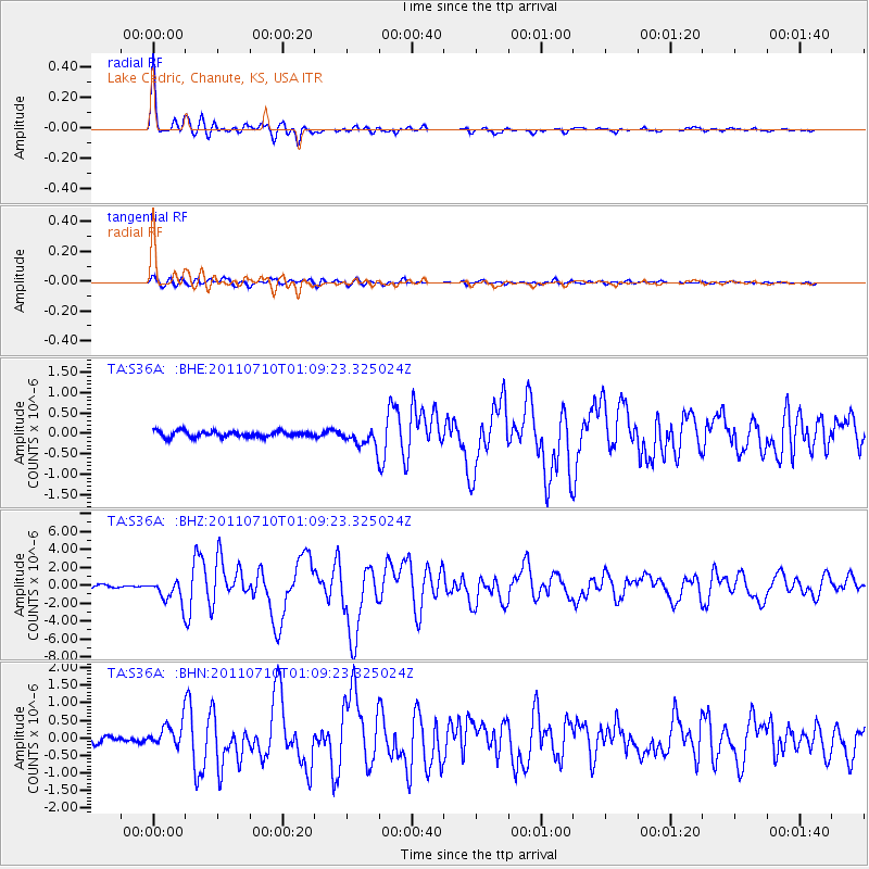
Signal To Noise
| Channel | StoN | STA | LTA |
| TA:S36A: :BHZ:20110710T01:09:23.325024Z | 10.057824 | 1.2617775E-6 | 1.2545232E-7 |
| TA:S36A: :BHN:20110710T01:09:23.325024Z | 4.4779167 | 3.4496622E-7 | 7.7037214E-8 |
| TA:S36A: :BHE:20110710T01:09:23.325024Z | 3.2895265 | 2.3610424E-7 | 7.177454E-8 |
| Arrivals |
| Ps | 5.0 SECOND |
| PpPs | 18 SECOND |
| PsPs/PpSs | 23 SECOND |


