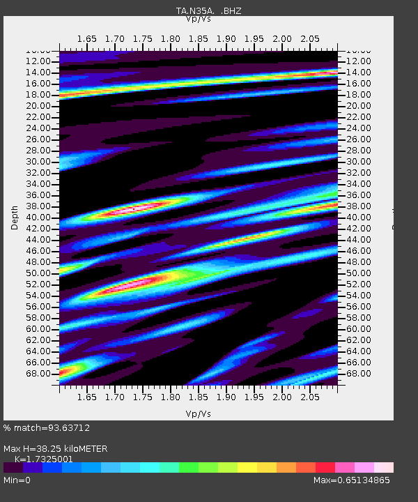
N35A Tabor, IA, USA - Earthquake Result Viewer
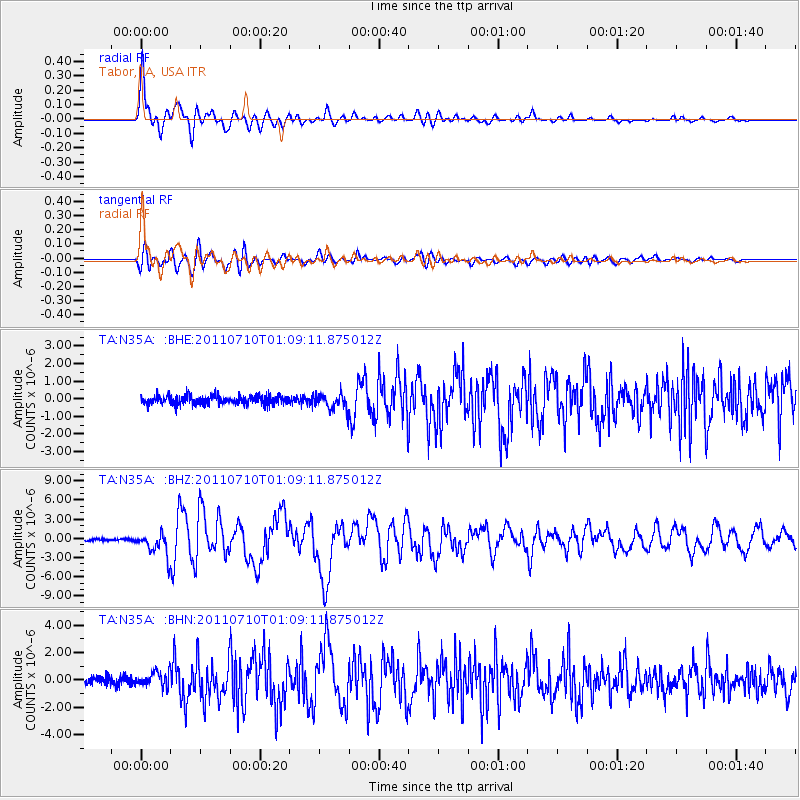
Earthquake location: Off East Coast Of Honshu, Japan
Earthquake latitude/longitude: 38.0/143.3
Earthquake time(UTC): 2011/07/10 (191) 00:57:10 GMT
Earthquake Depth: 23 km
Earthquake Magnitude: 6.6 MB, 7.0 MS, 7.0 MW, 7.0 MW
Earthquake Catalog/Contributor: WHDF/NEIC
Network: TA USArray Transportable Network (new EarthScope stations)
Station: N35A Tabor, IA, USA
Lat/Lon: 40.86 N/95.64 W
Elevation: 353 m
Distance: 84.8 deg
Az: 40.706 deg
Baz: 317.236 deg
Ray Param: 0.045196295
Estimated Moho Depth: 38.25 km
Estimated Crust Vp/Vs: 1.73
Assumed Crust Vp: 6.498 km/s
Estimated Crust Vs: 3.75 km/s
Estimated Crust Poisson's Ratio: 0.25
Radial Match: 93.63712 %
Radial Bump: 400
Transverse Match: 81.898705 %
Transverse Bump: 400
SOD ConfigId: 395004
Insert Time: 2011-12-16 06:42:56.741 +0000
GWidth: 2.5
Max Bumps: 400
Tol: 0.001

Signal To Noise

ChannelStoNSTALTA
TA:N35A: :BHZ:20110710T01:09:11.875012Z12.0820451.7774919E-61.4711847E-7
TA:N35A: :BHN:20110710T01:09:11.875012Z2.2807995.349197E-72.3453173E-7
TA:N35A: :BHE:20110710T01:09:11.875012Z1.85939134.5591608E-72.4519642E-7
Arrivals
Ps4.4 SECOND
PpPs16 SECOND
PsPs/PpSs20 SECOND