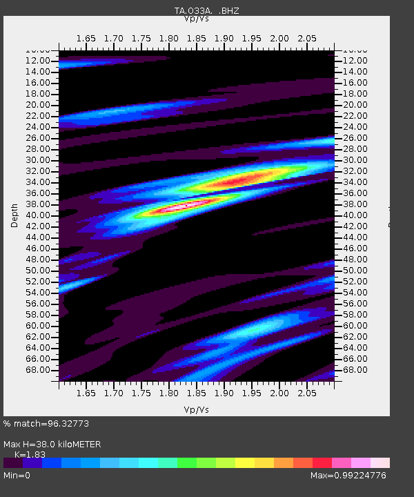
O33A Hebron, NE, USA - Earthquake Result Viewer
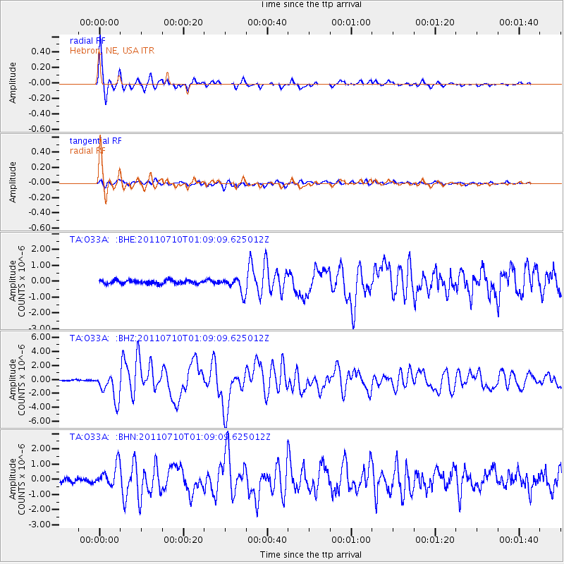
Earthquake location: Off East Coast Of Honshu, Japan
Earthquake latitude/longitude: 38.0/143.3
Earthquake time(UTC): 2011/07/10 (191) 00:57:10 GMT
Earthquake Depth: 23 km
Earthquake Magnitude: 6.6 MB, 7.0 MS, 7.0 MW, 7.0 MW
Earthquake Catalog/Contributor: WHDF/NEIC
Network: TA USArray Transportable Network (new EarthScope stations)
Station: O33A Hebron, NE, USA
Lat/Lon: 40.08 N/97.58 W
Elevation: 480 m
Distance: 84.4 deg
Az: 42.329 deg
Baz: 316.133 deg
Ray Param: 0.045516357
Estimated Moho Depth: 38.0 km
Estimated Crust Vp/Vs: 1.83
Assumed Crust Vp: 6.498 km/s
Estimated Crust Vs: 3.551 km/s
Estimated Crust Poisson's Ratio: 0.29
Radial Match: 96.32773 %
Radial Bump: 302
Transverse Match: 78.73824 %
Transverse Bump: 400
SOD ConfigId: 395004
Insert Time: 2011-12-16 06:43:38.975 +0000
GWidth: 2.5
Max Bumps: 400
Tol: 0.001

Signal To Noise

ChannelStoNSTALTA
TA:O33A: :BHZ:20110710T01:09:09.625012Z25.7255972.0433583E-67.942899E-8
TA:O33A: :BHN:20110710T01:09:09.625012Z6.43745957.515566E-71.167474E-7
TA:O33A: :BHE:20110710T01:09:09.625012Z4.45155675.092769E-71.1440424E-7
Arrivals
Ps5.0 SECOND
PpPs16 SECOND
PsPs/PpSs21 SECOND