Z36A Blue Ridge, TX, USA - Earthquake Result Viewer
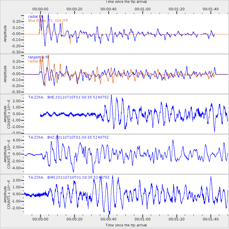
Earthquake location: Off East Coast Of Honshu, Japan
Earthquake latitude/longitude: 38.0/143.3
Earthquake time(UTC): 2011/07/10 (191) 00:57:10 GMT
Earthquake Depth: 23 km
Earthquake Magnitude: 6.6 MB, 7.0 MS, 7.0 MW, 7.0 MW
Earthquake Catalog/Contributor: WHDF/NEIC
Network: TA USArray Transportable Network (new EarthScope stations)
Station: Z36A Blue Ridge, TX, USA
Lat/Lon: 33.27 N/96.43 W
Elevation: 187 m
Distance: 89.9 deg
Az: 46.329 deg
Baz: 317.018 deg
Ray Param: 0.041707475
Estimated Moho Depth: 13.0 km
Estimated Crust Vp/Vs: 1.67
Assumed Crust Vp: 6.38 km/s
Estimated Crust Vs: 3.815 km/s
Estimated Crust Poisson's Ratio: 0.22
Radial Match: 92.27063 %
Radial Bump: 334
Transverse Match: 81.2423 %
Transverse Bump: 389
SOD ConfigId: 395004
Insert Time: 2011-12-16 06:44:31.749 +0000
GWidth: 2.5
Max Bumps: 400
Tol: 0.001

Signal To Noise

ChannelStoNSTALTA
TA:Z36A: :BHZ:20110710T01:09:36.524976Z7.36179979.908484E-71.3459324E-7
TA:Z36A: :BHN:20110710T01:09:36.524976Z0.989898261.8261268E-71.8447622E-7
TA:Z36A: :BHE:20110710T01:09:36.524976Z1.45346532.3508578E-71.6174158E-7
Arrivals
Ps1.4 SECOND
PpPs5.3 SECOND
PsPs/PpSs6.7 SECOND