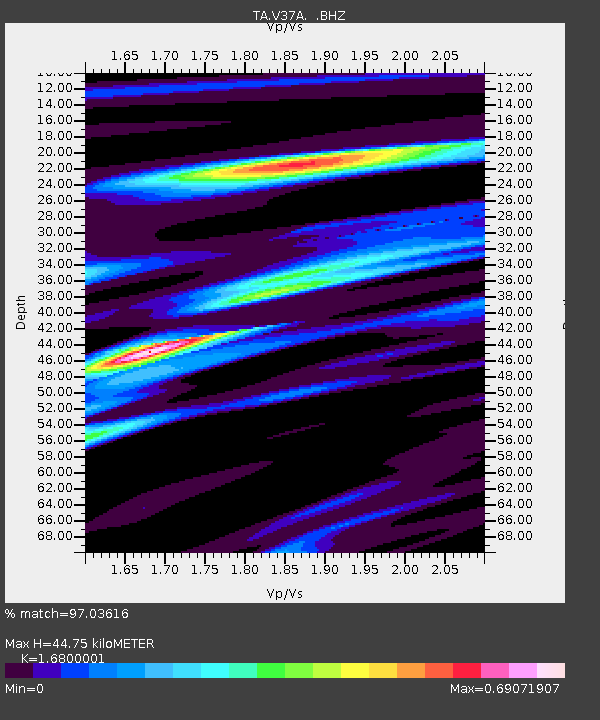
V37A Hulbert, OK, USA - Earthquake Result Viewer

Earthquake location: Off East Coast Of Honshu, Japan
Earthquake latitude/longitude: 38.0/143.3
Earthquake time(UTC): 2011/07/10 (191) 00:57:10 GMT
Earthquake Depth: 23 km
Earthquake Magnitude: 6.6 MB, 7.0 MS, 7.0 MW, 7.0 MW
Earthquake Catalog/Contributor: WHDF/NEIC
Network: TA USArray Transportable Network (new EarthScope stations)
Station: V37A Hulbert, OK, USA
Lat/Lon: 35.88 N/95.14 W
Elevation: 219 m
Distance: 88.7 deg
Az: 43.779 deg
Baz: 317.719 deg
Ray Param: 0.0423423
Estimated Moho Depth: 44.75 km
Estimated Crust Vp/Vs: 1.68
Assumed Crust Vp: 6.498 km/s
Estimated Crust Vs: 3.868 km/s
Estimated Crust Poisson's Ratio: 0.23
Radial Match: 97.03616 %
Radial Bump: 250
Transverse Match: 87.206726 %
Transverse Bump: 400
SOD ConfigId: 395004
Insert Time: 2011-12-16 06:45:00.597 +0000
GWidth: 2.5
Max Bumps: 400
Tol: 0.001

Signal To Noise

ChannelStoNSTALTA
TA:V37A: :BHZ:20110710T01:09:30.950024Z10.322078.662114E-78.391837E-8
TA:V37A: :BHN:20110710T01:09:30.950024Z4.2579992.612673E-76.1359174E-8
TA:V37A: :BHE:20110710T01:09:30.950024Z4.53218941.8865232E-74.162499E-8
Arrivals
Ps4.8 SECOND
PpPs18 SECOND
PsPs/PpSs23 SECOND