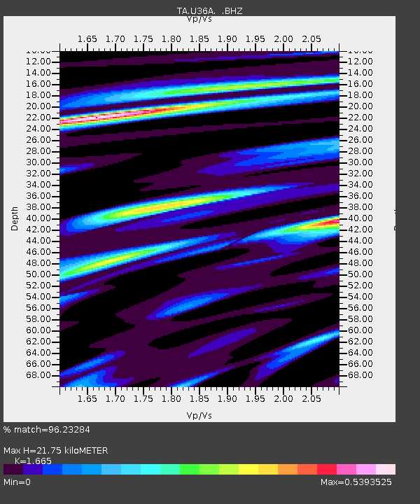
U36A Oologah, OK, USA - Earthquake Result Viewer
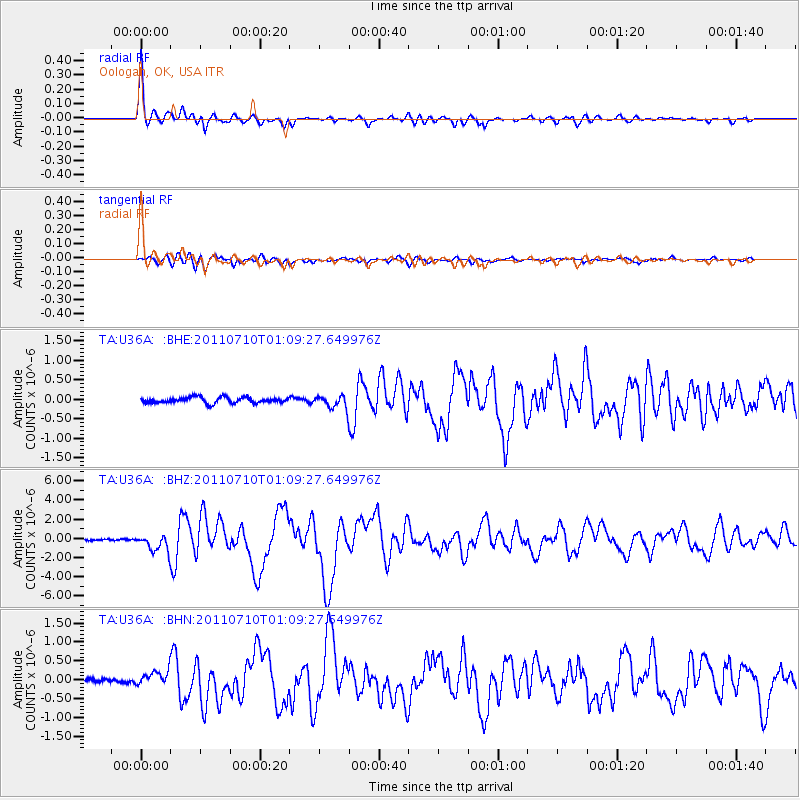
Earthquake location: Off East Coast Of Honshu, Japan
Earthquake latitude/longitude: 38.0/143.3
Earthquake time(UTC): 2011/07/10 (191) 00:57:10 GMT
Earthquake Depth: 23 km
Earthquake Magnitude: 6.6 MB, 7.0 MS, 7.0 MW, 7.0 MW
Earthquake Catalog/Contributor: WHDF/NEIC
Network: TA USArray Transportable Network (new EarthScope stations)
Station: U36A Oologah, OK, USA
Lat/Lon: 36.39 N/95.73 W
Elevation: 187 m
Distance: 88.0 deg
Az: 43.789 deg
Baz: 317.372 deg
Ray Param: 0.042862087
Estimated Moho Depth: 21.75 km
Estimated Crust Vp/Vs: 1.66
Assumed Crust Vp: 6.53 km/s
Estimated Crust Vs: 3.922 km/s
Estimated Crust Poisson's Ratio: 0.22
Radial Match: 96.23284 %
Radial Bump: 371
Transverse Match: 89.965866 %
Transverse Bump: 400
SOD ConfigId: 395004
Insert Time: 2011-12-16 06:45:55.675 +0000
GWidth: 2.5
Max Bumps: 400
Tol: 0.001

Signal To Noise

ChannelStoNSTALTA
TA:U36A: :BHZ:20110710T01:09:27.649976Z8.4043798.86638E-71.0549716E-7
TA:U36A: :BHN:20110710T01:09:27.649976Z2.53861452.0005957E-77.880659E-8
TA:U36A: :BHE:20110710T01:09:27.649976Z2.42891531.7835394E-77.342946E-8
Arrivals
Ps2.3 SECOND
PpPs8.7 SECOND
PsPs/PpSs11 SECOND