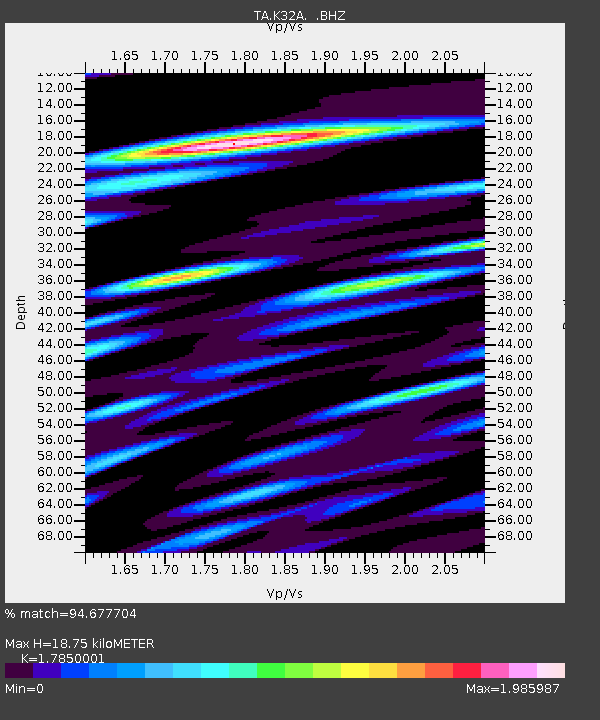
K32A Verdigre, NE, USA - Earthquake Result Viewer
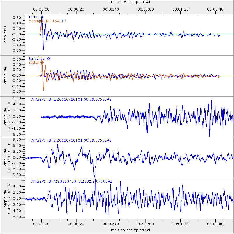
Earthquake location: Off East Coast Of Honshu, Japan
Earthquake latitude/longitude: 38.0/143.3
Earthquake time(UTC): 2011/07/10 (191) 00:57:10 GMT
Earthquake Depth: 23 km
Earthquake Magnitude: 6.6 MB, 7.0 MS, 7.0 MW, 7.0 MW
Earthquake Catalog/Contributor: WHDF/NEIC
Network: TA USArray Transportable Network (new EarthScope stations)
Station: K32A Verdigre, NE, USA
Lat/Lon: 42.66 N/97.97 W
Elevation: 512 m
Distance: 82.3 deg
Az: 40.732 deg
Baz: 315.692 deg
Ray Param: 0.046958517
Estimated Moho Depth: 18.75 km
Estimated Crust Vp/Vs: 1.79
Assumed Crust Vp: 6.498 km/s
Estimated Crust Vs: 3.64 km/s
Estimated Crust Poisson's Ratio: 0.27
Radial Match: 94.677704 %
Radial Bump: 400
Transverse Match: 89.2583 %
Transverse Bump: 400
SOD ConfigId: 395004
Insert Time: 2011-12-16 06:46:23.869 +0000
GWidth: 2.5
Max Bumps: 400
Tol: 0.001

Signal To Noise

ChannelStoNSTALTA
TA:K32A: :BHZ:20110710T01:08:59.075024Z16.223982.1785013E-61.3427662E-7
TA:K32A: :BHN:20110710T01:08:59.075024Z4.8971029.0203474E-71.8419766E-7
TA:K32A: :BHE:20110710T01:08:59.075024Z3.48663977.059909E-72.0248461E-7
Arrivals
Ps2.3 SECOND
PpPs7.8 SECOND
PsPs/PpSs10 SECOND