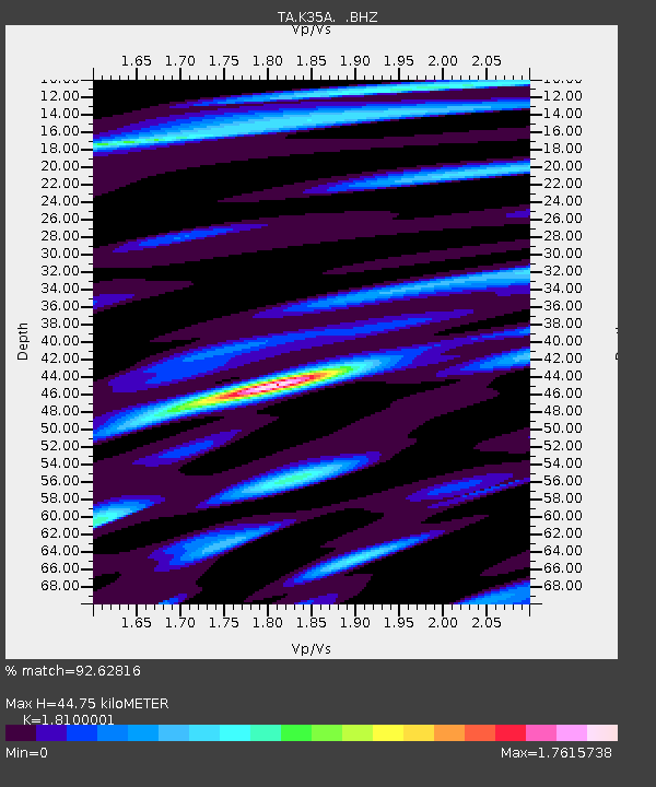
K35A Storm Lake, IA, USA - Earthquake Result Viewer
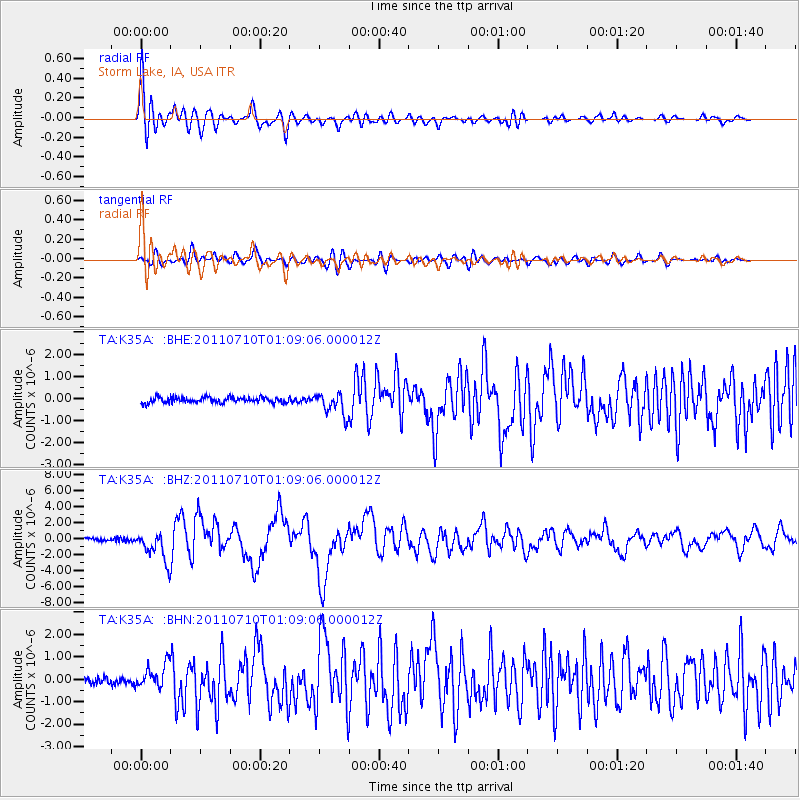
Earthquake location: Off East Coast Of Honshu, Japan
Earthquake latitude/longitude: 38.0/143.3
Earthquake time(UTC): 2011/07/10 (191) 00:57:10 GMT
Earthquake Depth: 23 km
Earthquake Magnitude: 6.6 MB, 7.0 MS, 7.0 MW, 7.0 MW
Earthquake Catalog/Contributor: WHDF/NEIC
Network: TA USArray Transportable Network (new EarthScope stations)
Station: K35A Storm Lake, IA, USA
Lat/Lon: 42.72 N/95.23 W
Elevation: 439 m
Distance: 83.6 deg
Az: 39.212 deg
Baz: 317.357 deg
Ray Param: 0.046016477
Estimated Moho Depth: 44.75 km
Estimated Crust Vp/Vs: 1.81
Assumed Crust Vp: 6.53 km/s
Estimated Crust Vs: 3.608 km/s
Estimated Crust Poisson's Ratio: 0.28
Radial Match: 92.62816 %
Radial Bump: 400
Transverse Match: 82.98663 %
Transverse Bump: 400
SOD ConfigId: 395004
Insert Time: 2011-12-16 06:47:24.174 +0000
GWidth: 2.5
Max Bumps: 400
Tol: 0.001

Signal To Noise

ChannelStoNSTALTA
TA:K35A: :BHZ:20110710T01:09:06.000012Z10.385561.8679708E-61.798623E-7
TA:K35A: :BHN:20110710T01:09:06.000012Z3.42262345.2553986E-71.5354884E-7
TA:K35A: :BHE:20110710T01:09:06.000012Z3.95577844.979149E-71.2587029E-7
Arrivals
Ps5.7 SECOND
PpPs19 SECOND
PsPs/PpSs24 SECOND