You are here: Home > Network List > TA - USArray Transportable Network (new EarthScope stations) Stations List
> Station H33A Prehn Over North, Clear Lake, SD, USA > Earthquake Result Viewer
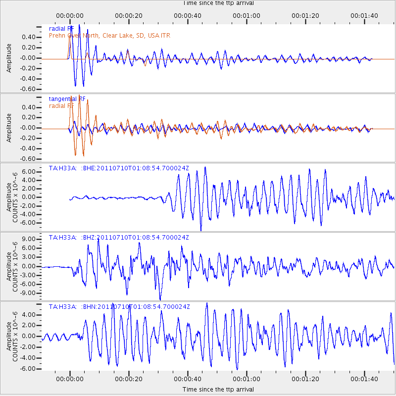
H33A Prehn Over North, Clear Lake, SD, USA - Earthquake Result Viewer

| Earthquake location: |
Off East Coast Of Honshu, Japan |
| Earthquake latitude/longitude: |
38.0/143.3 |
| Earthquake time(UTC): |
2011/07/10 (191) 00:57:10 GMT |
| Earthquake Depth: |
23 km |
| Earthquake Magnitude: |
6.6 MB, 7.0 MS, 7.0 MW, 7.0 MW |
| Earthquake Catalog/Contributor: |
WHDF/NEIC |
|
| Network: |
TA USArray Transportable Network (new EarthScope stations) |
| Station: |
H33A Prehn Over North, Clear Lake, SD, USA |
| Lat/Lon: |
44.68 N/96.74 W |
| Elevation: |
584 m |
|
| Distance: |
81.5 deg |
| Az: |
38.665 deg |
| Baz: |
316.246 deg |
| Ray Param: |
0.04754126 |
| Estimated Moho Depth: |
10.0 km |
| Estimated Crust Vp/Vs: |
1.60 |
| Assumed Crust Vp: |
6.552 km/s |
| Estimated Crust Vs: |
4.095 km/s |
| Estimated Crust Poisson's Ratio: |
0.18 |
|
| Radial Match: |
97.42397 % |
| Radial Bump: |
336 |
| Transverse Match: |
84.99591 % |
| Transverse Bump: |
400 |
| SOD ConfigId: |
395004 |
| Insert Time: |
2011-12-16 06:47:39.978 +0000 |
| GWidth: |
2.5 |
| Max Bumps: |
400 |
| Tol: |
0.001 |
|
Signal To Noise
| Channel | StoN | STA | LTA |
| TA:H33A: :BHZ:20110710T01:08:54.700024Z | 20.553232 | 2.1216379E-6 | 1.0322649E-7 |
| TA:H33A: :BHN:20110710T01:08:54.700024Z | 1.8819604 | 5.6866395E-7 | 3.0216574E-7 |
| TA:H33A: :BHE:20110710T01:08:54.700024Z | 4.411281 | 8.07557E-7 | 1.8306633E-7 |
| Arrivals |
| Ps | 0.9 SECOND |
| PpPs | 3.8 SECOND |
| PsPs/PpSs | 4.8 SECOND |


