You are here: Home > Network List > TA - USArray Transportable Network (new EarthScope stations) Stations List
> Station H32A Carlson Farm, Erwin, SD, USA > Earthquake Result Viewer
H32A Carlson Farm, Erwin, SD, USA - Earthquake Result Viewer
| Earthquake location: |
Off East Coast Of Honshu, Japan |
| Earthquake latitude/longitude: |
38.0/143.3 |
| Earthquake time(UTC): |
2011/07/10 (191) 00:57:10 GMT |
| Earthquake Depth: |
23 km |
| Earthquake Magnitude: |
6.6 MB, 7.0 MS, 7.0 MW, 7.0 MW |
| Earthquake Catalog/Contributor: |
WHDF/NEIC |
|
| Network: |
TA USArray Transportable Network (new EarthScope stations) |
| Station: |
H32A Carlson Farm, Erwin, SD, USA |
| Lat/Lon: |
44.50 N/97.44 W |
| Elevation: |
573 m |
|
| Distance: |
81.3 deg |
| Az: |
39.15 deg |
| Baz: |
315.834 deg |
| Ray Param: |
0.047693096 |
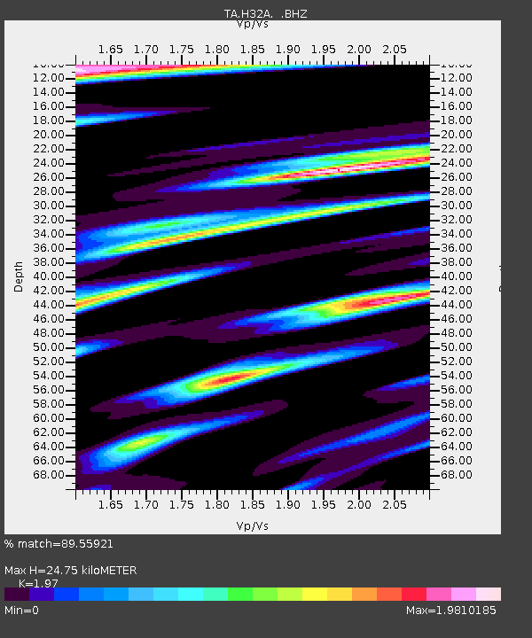
| Estimated Moho Depth: |
24.75 km |
| Estimated Crust Vp/Vs: |
1.97 |
| Assumed Crust Vp: |
6.552 km/s |
| Estimated Crust Vs: |
3.326 km/s |
| Estimated Crust Poisson's Ratio: |
0.33 |
|
| Radial Match: |
89.55921 % |
| Radial Bump: |
286 |
| Transverse Match: |
72.42426 % |
| Transverse Bump: |
400 |
| SOD ConfigId: |
395004 |
| Insert Time: |
2011-12-16 06:47:56.843 +0000 |
| GWidth: |
2.5 |
| Max Bumps: |
400 |
| Tol: |
0.001 |
|

Signal To Noise
| Channel | StoN | STA | LTA |
| TA:H32A: :BHZ:20110710T01:08:53.550Z | 21.669523 | 1.9589163E-6 | 9.039961E-8 |
| TA:H32A: :BHN:20110710T01:08:53.550Z | 3.003205 | 5.498325E-7 | 1.8308191E-7 |
| TA:H32A: :BHE:20110710T01:08:53.550Z | 3.0656948 | 7.3430436E-7 | 2.39523E-7 |
| Arrivals |
| Ps | 3.8 SECOND |
| PpPs | 11 SECOND |
| PsPs/PpSs | 15 SECOND |


