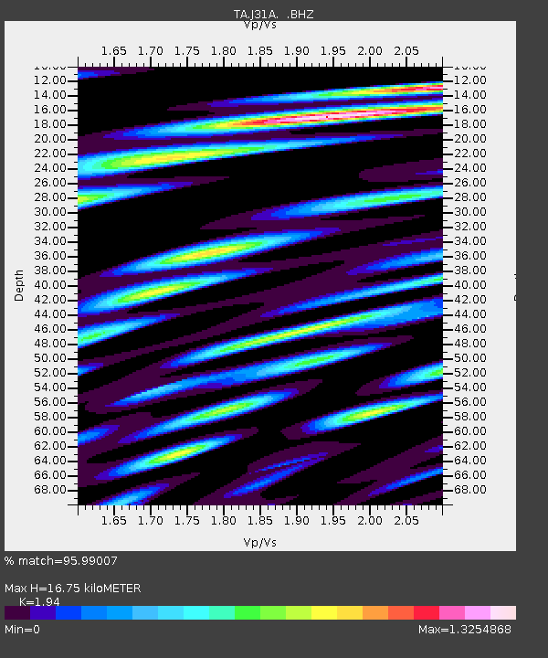
J31A Geddes, SD, USA - Earthquake Result Viewer
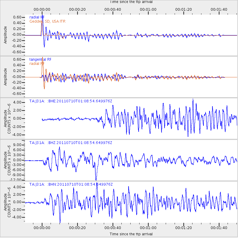
Earthquake location: Off East Coast Of Honshu, Japan
Earthquake latitude/longitude: 38.0/143.3
Earthquake time(UTC): 2011/07/10 (191) 00:57:10 GMT
Earthquake Depth: 23 km
Earthquake Magnitude: 6.6 MB, 7.0 MS, 7.0 MW, 7.0 MW
Earthquake Catalog/Contributor: WHDF/NEIC
Network: TA USArray Transportable Network (new EarthScope stations)
Station: J31A Geddes, SD, USA
Lat/Lon: 43.29 N/98.74 W
Elevation: 491 m
Distance: 81.5 deg
Az: 40.689 deg
Baz: 315.165 deg
Ray Param: 0.047549654
Estimated Moho Depth: 16.75 km
Estimated Crust Vp/Vs: 1.94
Assumed Crust Vp: 6.53 km/s
Estimated Crust Vs: 3.366 km/s
Estimated Crust Poisson's Ratio: 0.32
Radial Match: 95.99007 %
Radial Bump: 400
Transverse Match: 90.840256 %
Transverse Bump: 400
SOD ConfigId: 395004
Insert Time: 2011-12-16 06:48:07.683 +0000
GWidth: 2.5
Max Bumps: 400
Tol: 0.001

Signal To Noise

ChannelStoNSTALTA
TA:J31A: :BHZ:20110710T01:08:54.649976Z23.2665422.2315846E-69.59139E-8
TA:J31A: :BHN:20110710T01:08:54.649976Z7.79502157.3197765E-79.3903225E-8
TA:J31A: :BHE:20110710T01:08:54.649976Z4.14806276.098321E-71.4701612E-7
Arrivals
Ps2.5 SECOND
PpPs7.3 SECOND
PsPs/PpSs9.8 SECOND