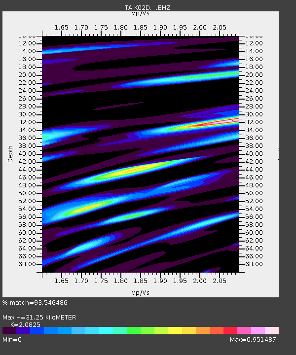
K02D Willamette Meridian, OR, USA - Earthquake Result Viewer
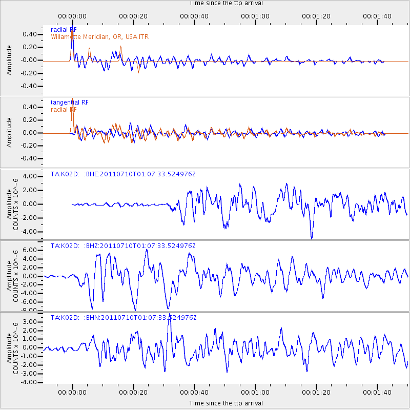
Earthquake location: Off East Coast Of Honshu, Japan
Earthquake latitude/longitude: 38.0/143.3
Earthquake time(UTC): 2011/07/10 (191) 00:57:10 GMT
Earthquake Depth: 23 km
Earthquake Magnitude: 6.6 MB, 7.0 MS, 7.0 MW, 7.0 MW
Earthquake Catalog/Contributor: WHDF/NEIC
Network: TA USArray Transportable Network (new EarthScope stations)
Station: K02D Willamette Meridian, OR, USA
Lat/Lon: 42.70 N/123.67 W
Elevation: 989 m
Distance: 67.5 deg
Az: 52.851 deg
Baz: 301.379 deg
Ray Param: 0.056915756
Estimated Moho Depth: 31.25 km
Estimated Crust Vp/Vs: 2.08
Assumed Crust Vp: 6.522 km/s
Estimated Crust Vs: 3.132 km/s
Estimated Crust Poisson's Ratio: 0.35
Radial Match: 93.546486 %
Radial Bump: 400
Transverse Match: 85.93968 %
Transverse Bump: 400
SOD ConfigId: 395004
Insert Time: 2011-12-16 06:48:28.544 +0000
GWidth: 2.5
Max Bumps: 400
Tol: 0.001

Signal To Noise

ChannelStoNSTALTA
TA:K02D: :BHZ:20110710T01:07:33.524976Z6.9493371.1313437E-61.6279878E-7
TA:K02D: :BHN:20110710T01:07:33.524976Z2.10806473.6342993E-71.723998E-7
TA:K02D: :BHE:20110710T01:07:33.524976Z2.92763194.0007887E-71.3665614E-7
Arrivals
Ps5.4 SECOND
PpPs14 SECOND
PsPs/PpSs20 SECOND