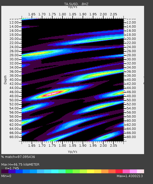
SUSD Miller, SD, USA - Earthquake Result Viewer

Earthquake location: Off East Coast Of Honshu, Japan
Earthquake latitude/longitude: 38.0/143.3
Earthquake time(UTC): 2011/07/10 (191) 00:57:10 GMT
Earthquake Depth: 23 km
Earthquake Magnitude: 6.6 MB, 7.0 MS, 7.0 MW, 7.0 MW
Earthquake Catalog/Contributor: WHDF/NEIC
Network: TA USArray Transportable Network (new EarthScope stations)
Station: SUSD Miller, SD, USA
Lat/Lon: 44.44 N/98.96 W
Elevation: 520 m
Distance: 80.5 deg
Az: 39.978 deg
Baz: 314.905 deg
Ray Param: 0.048188783
Estimated Moho Depth: 46.75 km
Estimated Crust Vp/Vs: 1.75
Assumed Crust Vp: 6.53 km/s
Estimated Crust Vs: 3.742 km/s
Estimated Crust Poisson's Ratio: 0.26
Radial Match: 97.095436 %
Radial Bump: 340
Transverse Match: 95.50661 %
Transverse Bump: 389
SOD ConfigId: 395004
Insert Time: 2011-12-16 06:50:37.227 +0000
GWidth: 2.5
Max Bumps: 400
Tol: 0.001

Signal To Noise

ChannelStoNSTALTA
TA:SUSD: :BHZ:20110710T01:08:49.724988Z19.436012.2754052E-61.1707162E-7
TA:SUSD: :BHN:20110710T01:08:49.724988Z2.69773365.811208E-72.1541074E-7
TA:SUSD: :BHE:20110710T01:08:49.724988Z5.90530548.6605235E-71.4665665E-7
Arrivals
Ps5.5 SECOND
PpPs19 SECOND
PsPs/PpSs25 SECOND