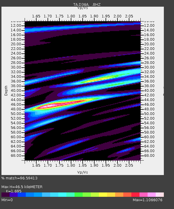
D36A Goodland, MN, USA - Earthquake Result Viewer
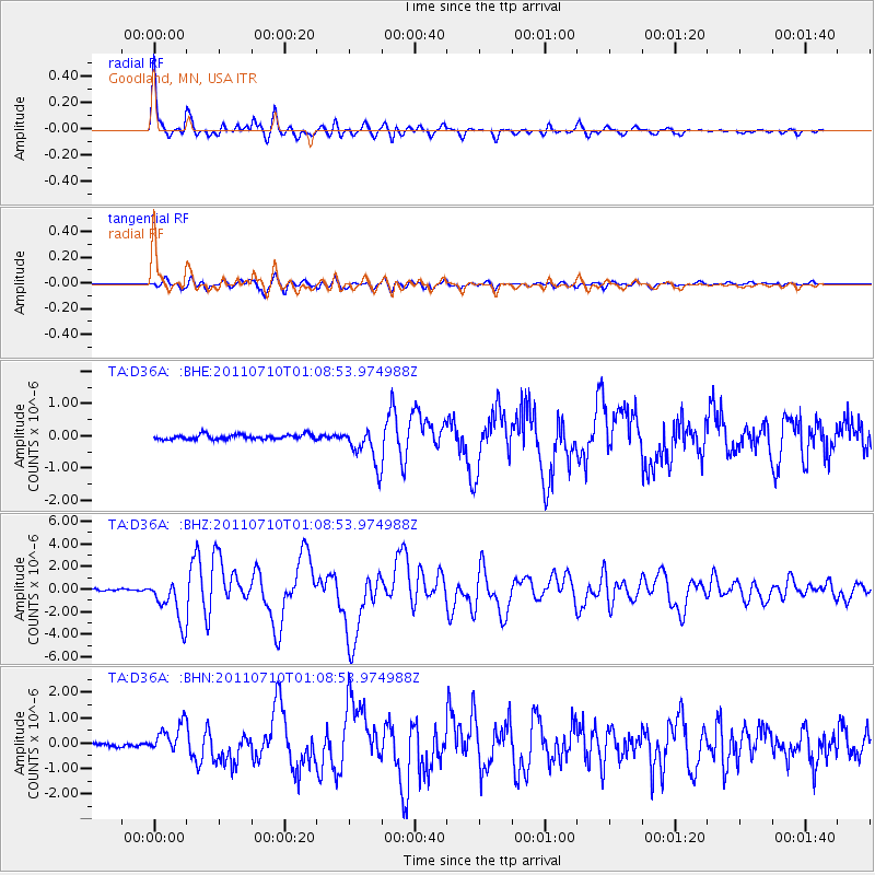
Earthquake location: Off East Coast Of Honshu, Japan
Earthquake latitude/longitude: 38.0/143.3
Earthquake time(UTC): 2011/07/10 (191) 00:57:10 GMT
Earthquake Depth: 23 km
Earthquake Magnitude: 6.6 MB, 7.0 MS, 7.0 MW, 7.0 MW
Earthquake Catalog/Contributor: WHDF/NEIC
Network: TA USArray Transportable Network (new EarthScope stations)
Station: D36A Goodland, MN, USA
Lat/Lon: 47.18 N/93.16 W
Elevation: 434 m
Distance: 81.3 deg
Az: 35.098 deg
Baz: 318.277 deg
Ray Param: 0.047637574
Estimated Moho Depth: 46.5 km
Estimated Crust Vp/Vs: 1.70
Assumed Crust Vp: 6.571 km/s
Estimated Crust Vs: 3.876 km/s
Estimated Crust Poisson's Ratio: 0.23
Radial Match: 96.59413 %
Radial Bump: 379
Transverse Match: 86.46475 %
Transverse Bump: 400
SOD ConfigId: 395004
Insert Time: 2011-12-16 06:51:47.037 +0000
GWidth: 2.5
Max Bumps: 400
Tol: 0.001

Signal To Noise

ChannelStoNSTALTA
TA:D36A: :BHZ:20110710T01:08:53.974988Z21.6155851.9475253E-69.0098204E-8
TA:D36A: :BHN:20110710T01:08:53.974988Z7.4378415.66921E-77.622118E-8
TA:D36A: :BHE:20110710T01:08:53.974988Z7.79916335.869651E-77.5260004E-8
Arrivals
Ps5.1 SECOND
PpPs19 SECOND
PsPs/PpSs24 SECOND