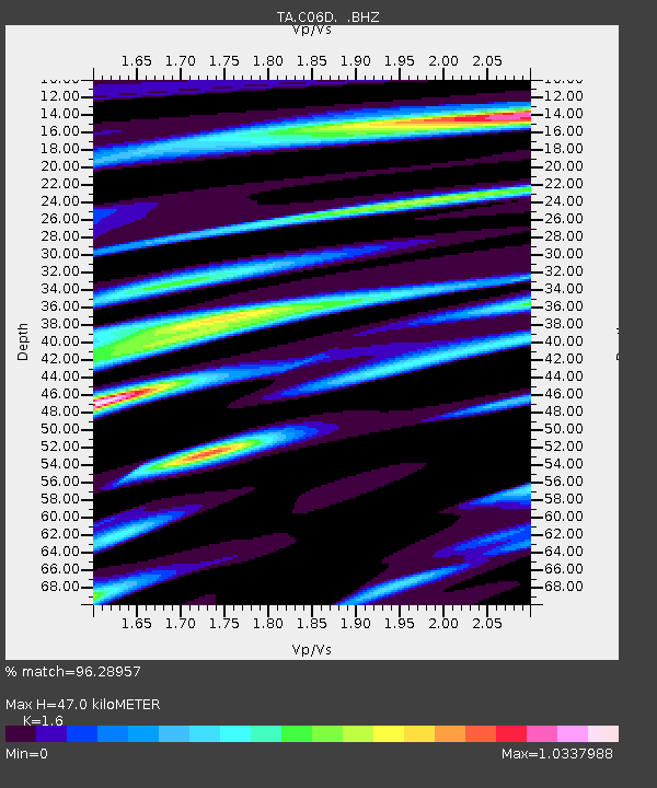
C06D Leavenworth, WQ, USA - Earthquake Result Viewer
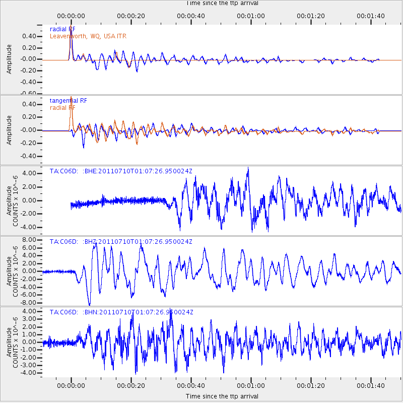
Earthquake location: Off East Coast Of Honshu, Japan
Earthquake latitude/longitude: 38.0/143.3
Earthquake time(UTC): 2011/07/10 (191) 00:57:10 GMT
Earthquake Depth: 23 km
Earthquake Magnitude: 6.6 MB, 7.0 MS, 7.0 MW, 7.0 MW
Earthquake Catalog/Contributor: WHDF/NEIC
Network: TA USArray Transportable Network (new EarthScope stations)
Station: C06D Leavenworth, WQ, USA
Lat/Lon: 47.92 N/120.89 W
Elevation: 544 m
Distance: 66.4 deg
Az: 46.891 deg
Baz: 301.008 deg
Ray Param: 0.057597898
Estimated Moho Depth: 47.0 km
Estimated Crust Vp/Vs: 1.60
Assumed Crust Vp: 6.597 km/s
Estimated Crust Vs: 4.123 km/s
Estimated Crust Poisson's Ratio: 0.18
Radial Match: 96.28957 %
Radial Bump: 400
Transverse Match: 85.06179 %
Transverse Bump: 400
SOD ConfigId: 395004
Insert Time: 2011-12-16 06:52:04.873 +0000
GWidth: 2.5
Max Bumps: 400
Tol: 0.001

Signal To Noise

ChannelStoNSTALTA
TA:C06D: :BHZ:20110710T01:07:26.950024Z8.4691271.3111629E-61.5481679E-7
TA:C06D: :BHN:20110710T01:07:26.950024Z1.46537034.3696272E-72.981927E-7
TA:C06D: :BHE:20110710T01:07:26.950024Z1.29504814.6000707E-73.552046E-7
Arrivals
Ps4.5 SECOND
PpPs18 SECOND
PsPs/PpSs22 SECOND