You are here: Home > Network List > TA - USArray Transportable Network (new EarthScope stations) Stations List
> Station R11A Troy Canyon, Currant, NV, USA > Earthquake Result Viewer
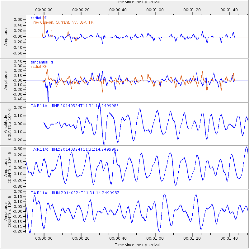
R11A Troy Canyon, Currant, NV, USA - Earthquake Result Viewer
*The percent match for this event was below the threshold and hence no stack was calculated.
| Earthquake location: |
Near Coast Of Nicaragua |
| Earthquake latitude/longitude: |
11.7/-87.0 |
| Earthquake time(UTC): |
2014/03/24 (083) 11:24:42 GMT |
| Earthquake Depth: |
61 km |
| Earthquake Magnitude: |
4.5 mb |
| Earthquake Catalog/Contributor: |
ISC/ISC |
|
| Network: |
TA USArray Transportable Network (new EarthScope stations) |
| Station: |
R11A Troy Canyon, Currant, NV, USA |
| Lat/Lon: |
38.35 N/115.59 W |
| Elevation: |
1756 m |
|
| Distance: |
36.8 deg |
| Az: |
321.079 deg |
| Baz: |
128.505 deg |
| Ray Param: |
$rayparam |
*The percent match for this event was below the threshold and hence was not used in the summary stack. |
|
| Radial Match: |
47.84281 % |
| Radial Bump: |
377 |
| Transverse Match: |
70.4638 % |
| Transverse Bump: |
353 |
| SOD ConfigId: |
3390531 |
| Insert Time: |
2019-04-10 21:04:00.148 +0000 |
| GWidth: |
2.5 |
| Max Bumps: |
400 |
| Tol: |
0.001 |
|
Signal To Noise
| Channel | StoN | STA | LTA |
| TA:R11A: :BHZ:20140324T11:31:14.249998Z | 0.9768758 | 9.66964E-8 | 9.898536E-8 |
| TA:R11A: :BHN:20140324T11:31:14.249998Z | 1.2337642 | 9.578578E-8 | 7.7637026E-8 |
| TA:R11A: :BHE:20140324T11:31:14.249998Z | 4.2772017 | 1.7201984E-7 | 4.021785E-8 |
| Arrivals |
| Ps | |
| PpPs | |
| PsPs/PpSs | |


