You are here: Home > Network List > TA - USArray Transportable Network (new EarthScope stations) Stations List
> Station C38A Sawbill Landing (USFS), Superior Nat. Forest, MN, > Earthquake Result Viewer
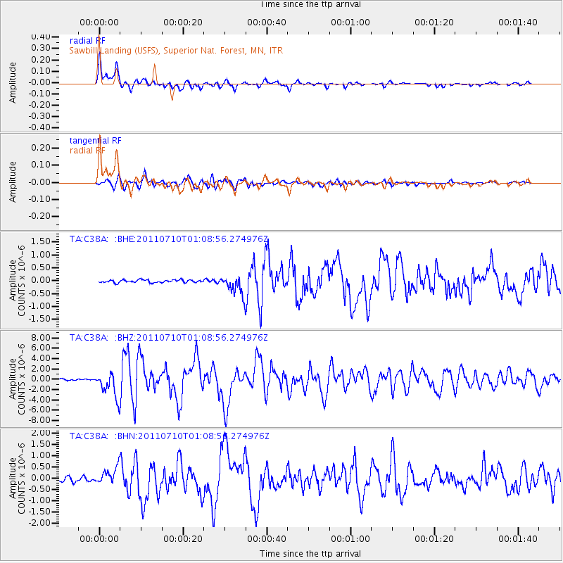
C38A Sawbill Landing (USFS), Superior Nat. Forest, MN, - Earthquake Result Viewer
| Earthquake location: |
Off East Coast Of Honshu, Japan |
| Earthquake latitude/longitude: |
38.0/143.3 |
| Earthquake time(UTC): |
2011/07/10 (191) 00:57:10 GMT |
| Earthquake Depth: |
23 km |
| Earthquake Magnitude: |
6.6 MB, 7.0 MS, 7.0 MW, 7.0 MW |
| Earthquake Catalog/Contributor: |
WHDF/NEIC |
|
| Network: |
TA USArray Transportable Network (new EarthScope stations) |
| Station: |
C38A Sawbill Landing (USFS), Superior Nat. Forest, MN, |
| Lat/Lon: |
47.72 N/91.27 W |
| Elevation: |
498 m |
|
| Distance: |
81.8 deg |
| Az: |
33.76 deg |
| Baz: |
319.469 deg |
| Ray Param: |
0.047330685 |
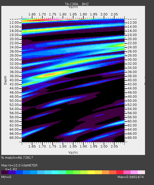
| Estimated Moho Depth: |
10.0 km |
| Estimated Crust Vp/Vs: |
1.82 |
| Assumed Crust Vp: |
6.467 km/s |
| Estimated Crust Vs: |
3.553 km/s |
| Estimated Crust Poisson's Ratio: |
0.28 |
|
| Radial Match: |
96.72917 % |
| Radial Bump: |
400 |
| Transverse Match: |
91.266136 % |
| Transverse Bump: |
400 |
| SOD ConfigId: |
395004 |
| Insert Time: |
2011-12-16 06:53:42.106 +0000 |
| GWidth: |
2.5 |
| Max Bumps: |
400 |
| Tol: |
0.001 |
|
Signal To Noise
| Channel | StoN | STA | LTA |
| TA:C38A: :BHZ:20110710T01:08:56.274976Z | 22.791494 | 2.527046E-6 | 1.1087672E-7 |
| TA:C38A: :BHN:20110710T01:08:56.274976Z | 4.337683 | 3.8286183E-7 | 8.826412E-8 |
| TA:C38A: :BHE:20110710T01:08:56.274976Z | 7.394556 | 3.861977E-7 | 5.2227303E-8 |
| Arrivals |
| Ps | 1.3 SECOND |
| PpPs | 4.2 SECOND |
| PsPs/PpSs | 5.5 SECOND |


