You are here: Home > Network List > G - GEOSCOPE Stations List
> Station CAN Canberra, Australia > Earthquake Result Viewer
CAN Canberra, Australia - Earthquake Result Viewer
| Earthquake location: |
Near N Coast Of New Guinea, P.N.G. |
| Earthquake latitude/longitude: |
-2.4/141.2 |
| Earthquake time(UTC): |
1992/10/31 (305) 14:34:26 GMT |
| Earthquake Depth: |
33 km |
| Earthquake Magnitude: |
5.8 MB, 6.4 MS |
| Earthquake Catalog/Contributor: |
WHDF/NEIC |
|
| Network: |
G GEOSCOPE |
| Station: |
CAN Canberra, Australia |
| Lat/Lon: |
35.32 S/149.00 E |
| Elevation: |
650 m |
|
| Distance: |
33.6 deg |
| Az: |
168.453 deg |
| Baz: |
345.844 deg |
| Ray Param: |
0.07810023 |
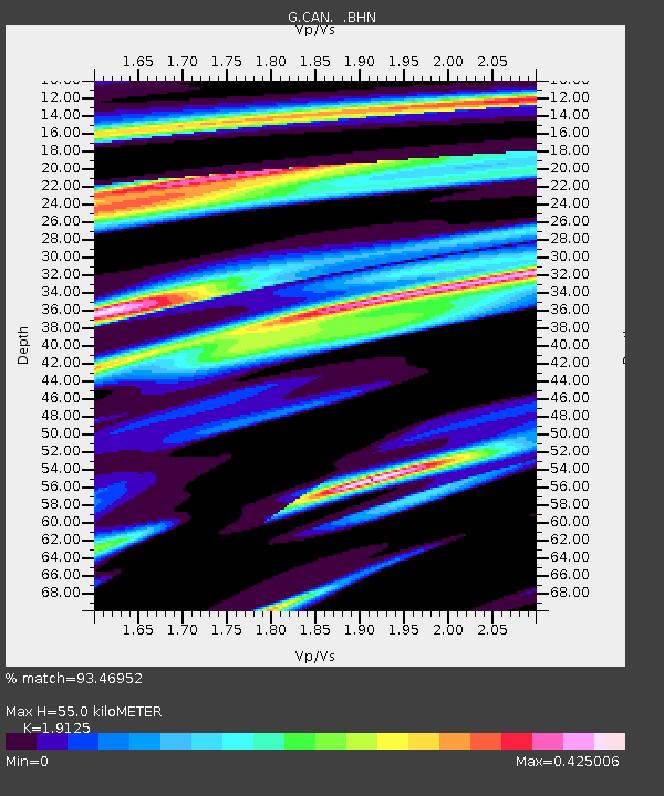
| Estimated Moho Depth: |
55.0 km |
| Estimated Crust Vp/Vs: |
1.91 |
| Assumed Crust Vp: |
6.633 km/s |
| Estimated Crust Vs: |
3.468 km/s |
| Estimated Crust Poisson's Ratio: |
0.31 |
|
| Radial Match: |
93.46952 % |
| Radial Bump: |
219 |
| Transverse Match: |
85.145195 % |
| Transverse Bump: |
400 |
| SOD ConfigId: |
16938 |
| Insert Time: |
2010-02-26 21:38:27.293 +0000 |
| GWidth: |
2.5 |
| Max Bumps: |
400 |
| Tol: |
0.001 |
|

Signal To Noise
| Channel | StoN | STA | LTA |
| G:CAN: :BHN:19921031T14:40:33.150012Z | 1.7867886 | 5.8964145E-7 | 3.300007E-7 |
| G:CAN: :BHE:19921031T14:40:33.150012Z | 1.215702 | 3.1946595E-7 | 2.627831E-7 |
| G:CAN: :BHZ:19921031T14:40:33.150012Z | 2.2904 | 8.502678E-7 | 3.7123112E-7 |
| Arrivals |
| Ps | 8.2 SECOND |
| PpPs | 22 SECOND |
| PsPs/PpSs | 31 SECOND |


