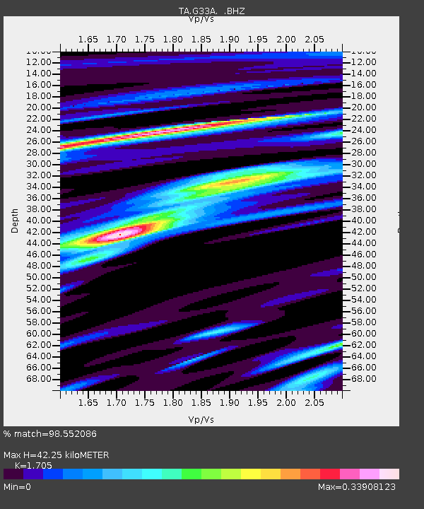
G33A Ortonville, MN, USA - Earthquake Result Viewer
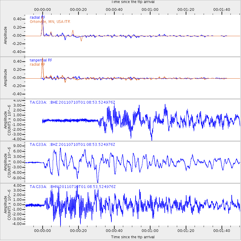
Earthquake location: Off East Coast Of Honshu, Japan
Earthquake latitude/longitude: 38.0/143.3
Earthquake time(UTC): 2011/07/10 (191) 00:57:10 GMT
Earthquake Depth: 23 km
Earthquake Magnitude: 6.6 MB, 7.0 MS, 7.0 MW, 7.0 MW
Earthquake Catalog/Contributor: WHDF/NEIC
Network: TA USArray Transportable Network (new EarthScope stations)
Station: G33A Ortonville, MN, USA
Lat/Lon: 45.19 N/96.44 W
Elevation: 338 m
Distance: 81.2 deg
Az: 38.148 deg
Baz: 316.383 deg
Ray Param: 0.04769689
Estimated Moho Depth: 42.25 km
Estimated Crust Vp/Vs: 1.71
Assumed Crust Vp: 6.552 km/s
Estimated Crust Vs: 3.843 km/s
Estimated Crust Poisson's Ratio: 0.24
Radial Match: 98.552086 %
Radial Bump: 234
Transverse Match: 88.97841 %
Transverse Bump: 400
SOD ConfigId: 395004
Insert Time: 2011-12-16 06:54:37.504 +0000
GWidth: 2.5
Max Bumps: 400
Tol: 0.001

Signal To Noise

ChannelStoNSTALTA
TA:G33A: :BHZ:20110710T01:08:53.524976Z18.5172732.2246347E-61.2013835E-7
TA:G33A: :BHN:20110710T01:08:53.524976Z6.18569338.1758E-71.3217273E-7
TA:G33A: :BHE:20110710T01:08:53.524976Z4.63072357.032258E-71.5186089E-7
Arrivals
Ps4.7 SECOND
PpPs17 SECOND
PsPs/PpSs22 SECOND