You are here: Home > Network List > TA - USArray Transportable Network (new EarthScope stations) Stations List
> Station J38A Wedel Dairy, Riceville, IA, USA > Earthquake Result Viewer
J38A Wedel Dairy, Riceville, IA, USA - Earthquake Result Viewer

| Earthquake location: |
Off East Coast Of Honshu, Japan |
| Earthquake latitude/longitude: |
38.0/143.3 |
| Earthquake time(UTC): |
2011/07/10 (191) 00:57:10 GMT |
| Earthquake Depth: |
23 km |
| Earthquake Magnitude: |
6.6 MB, 7.0 MS, 7.0 MW, 7.0 MW |
| Earthquake Catalog/Contributor: |
WHDF/NEIC |
|
| Network: |
TA USArray Transportable Network (new EarthScope stations) |
| Station: |
J38A Wedel Dairy, Riceville, IA, USA |
| Lat/Lon: |
43.32 N/92.48 W |
| Elevation: |
371 m |
|
| Distance: |
84.5 deg |
| Az: |
37.297 deg |
| Baz: |
319.035 deg |
| Ray Param: |
0.045379803 |
| Estimated Moho Depth: |
45.75 km |
| Estimated Crust Vp/Vs: |
1.66 |
| Assumed Crust Vp: |
6.53 km/s |
| Estimated Crust Vs: |
3.934 km/s |
| Estimated Crust Poisson's Ratio: |
0.22 |
|
| Radial Match: |
96.12025 % |
| Radial Bump: |
331 |
| Transverse Match: |
93.50535 % |
| Transverse Bump: |
400 |
| SOD ConfigId: |
395004 |
| Insert Time: |
2011-12-16 06:55:11.420 +0000 |
| GWidth: |
2.5 |
| Max Bumps: |
400 |
| Tol: |
0.001 |
|
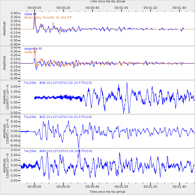
Signal To Noise
| Channel | StoN | STA | LTA |
| TA:J38A: :BHZ:20110710T01:09:10.575024Z | 18.690884 | 1.9714307E-6 | 1.0547552E-7 |
| TA:J38A: :BHN:20110710T01:09:10.575024Z | 2.7131078 | 6.059879E-7 | 2.2335563E-7 |
| TA:J38A: :BHE:20110710T01:09:10.575024Z | 1.8143936 | 3.2924342E-7 | 1.8146196E-7 |
| Arrivals |
| Ps | 4.8 SECOND |
| PpPs | 18 SECOND |
| PsPs/PpSs | 23 SECOND |


