You are here: Home > Network List > G - GEOSCOPE Stations List
> Station CAN Canberra, Australia > Earthquake Result Viewer
CAN Canberra, Australia - Earthquake Result Viewer
| Earthquake location: |
Fiji Islands Region |
| Earthquake latitude/longitude: |
-15.8/-179.7 |
| Earthquake time(UTC): |
1992/11/08 (313) 03:43:23 GMT |
| Earthquake Depth: |
33 km |
| Earthquake Magnitude: |
5.7 MB, 6.5 MS, 6.6 UNKNOWN |
| Earthquake Catalog/Contributor: |
WHDF/NEIC |
|
| Network: |
G GEOSCOPE |
| Station: |
CAN Canberra, Australia |
| Lat/Lon: |
35.32 S/149.00 E |
| Elevation: |
650 m |
|
| Distance: |
34.1 deg |
| Az: |
229.271 deg |
| Baz: |
63.164 deg |
| Ray Param: |
0.07786083 |
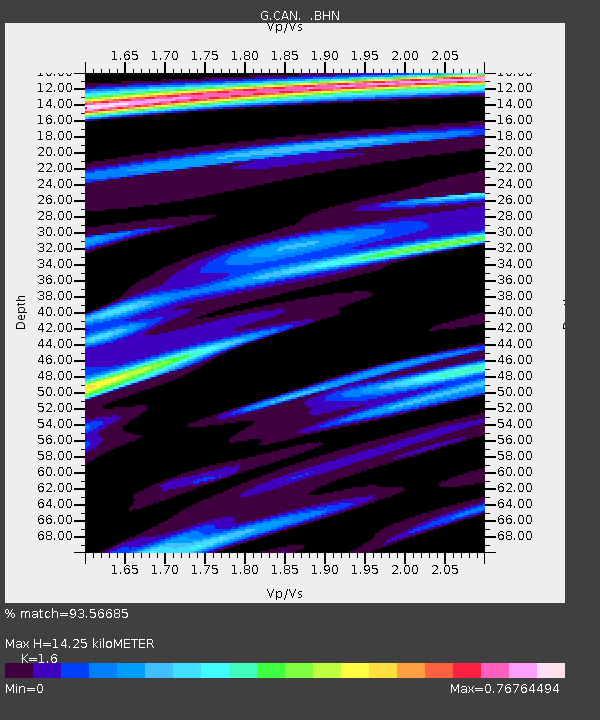
| Estimated Moho Depth: |
14.25 km |
| Estimated Crust Vp/Vs: |
1.60 |
| Assumed Crust Vp: |
6.633 km/s |
| Estimated Crust Vs: |
4.146 km/s |
| Estimated Crust Poisson's Ratio: |
0.18 |
|
| Radial Match: |
93.56685 % |
| Radial Bump: |
298 |
| Transverse Match: |
63.73097 % |
| Transverse Bump: |
400 |
| SOD ConfigId: |
16938 |
| Insert Time: |
2010-02-26 21:38:34.791 +0000 |
| GWidth: |
2.5 |
| Max Bumps: |
400 |
| Tol: |
0.001 |
|
Signal To Noise
| Channel | StoN | STA | LTA |
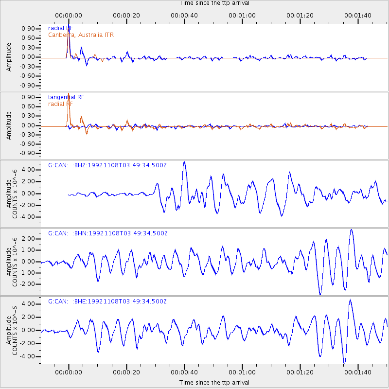
| G:CAN: :BHN:19921108T03:49:34.500Z | 2.6945026 | 3.7739855E-7 | 1.4006243E-7 |
| G:CAN: :BHE:19921108T03:49:34.500Z | 4.655964 | 7.7925785E-7 | 1.6736767E-7 |
| G:CAN: :BHZ:19921108T03:49:34.500Z | 8.999659 | 1.5363689E-6 | 1.7071415E-7 |
| Arrivals |
| Ps | 1.4 SECOND |
| PpPs | 5.1 SECOND |
| PsPs/PpSs | 6.5 SECOND |


