You are here: Home > Network List > TA - USArray Transportable Network (new EarthScope stations) Stations List
> Station O56A Blue Knob State Park, Imler, PA, USA > Earthquake Result Viewer
O56A Blue Knob State Park, Imler, PA, USA - Earthquake Result Viewer
| Earthquake location: |
Off East Coast Of Honshu, Japan |
| Earthquake latitude/longitude: |
38.0/143.3 |
| Earthquake time(UTC): |
2011/07/10 (191) 00:57:10 GMT |
| Earthquake Depth: |
23 km |
| Earthquake Magnitude: |
6.6 MB, 7.0 MS, 7.0 MW, 7.0 MW |
| Earthquake Catalog/Contributor: |
WHDF/NEIC |
|
| Network: |
TA USArray Transportable Network (new EarthScope stations) |
| Station: |
O56A Blue Knob State Park, Imler, PA, USA |
| Lat/Lon: |
40.27 N/78.57 W |
| Elevation: |
684 m |
|
| Distance: |
93.2 deg |
| Az: |
30.736 deg |
| Baz: |
328.167 deg |
| Ray Param: |
0.0413092 |
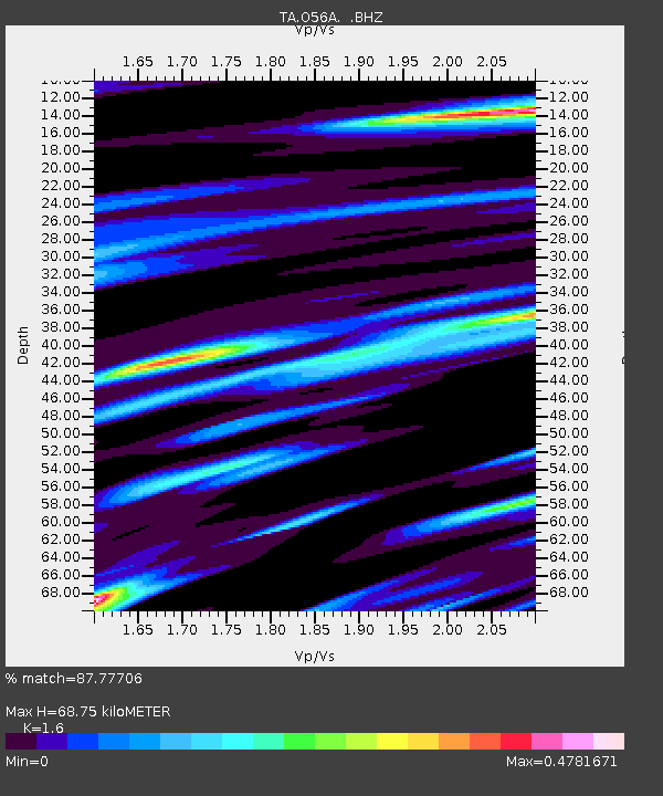
| Estimated Moho Depth: |
68.75 km |
| Estimated Crust Vp/Vs: |
1.60 |
| Assumed Crust Vp: |
6.121 km/s |
| Estimated Crust Vs: |
3.825 km/s |
| Estimated Crust Poisson's Ratio: |
0.18 |
|
| Radial Match: |
87.77706 % |
| Radial Bump: |
400 |
| Transverse Match: |
76.37958 % |
| Transverse Bump: |
400 |
| SOD ConfigId: |
395004 |
| Insert Time: |
2011-12-16 06:57:03.459 +0000 |
| GWidth: |
2.5 |
| Max Bumps: |
400 |
| Tol: |
0.001 |
|

Signal To Noise
| Channel | StoN | STA | LTA |
| TA:O56A: :BHZ:20110710T01:09:51.450024Z | 1.8955206 | 4.4054528E-7 | 2.3241387E-7 |
| TA:O56A: :BHN:20110710T01:09:51.450024Z | 1.5190351 | 1.43139E-7 | 9.423022E-8 |
| TA:O56A: :BHE:20110710T01:09:51.450024Z | 1.3283535 | 1.6781676E-7 | 1.2633441E-7 |
| Arrivals |
| Ps | 6.9 SECOND |
| PpPs | 29 SECOND |
| PsPs/PpSs | 35 SECOND |


