P38A Dawn, MO, USA - Earthquake Result Viewer
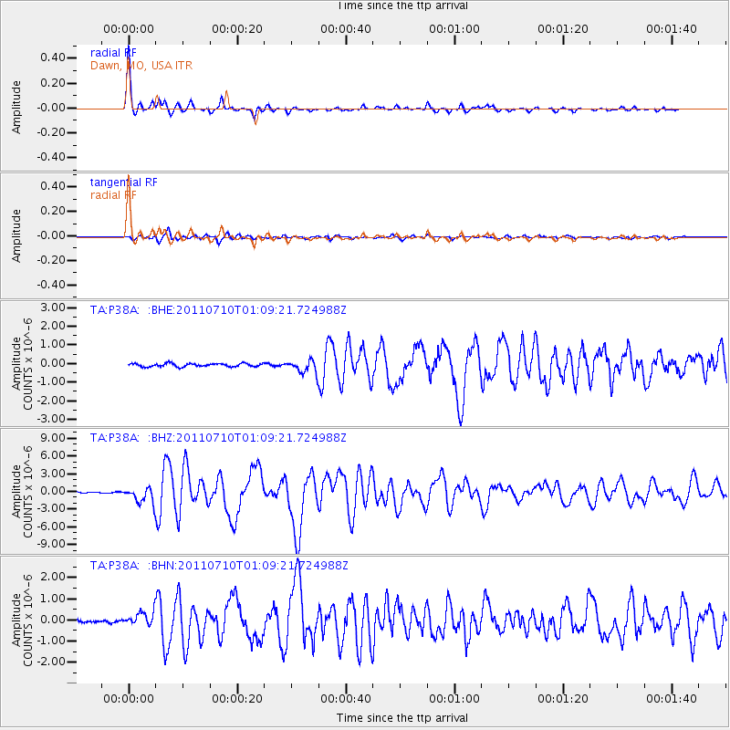
Earthquake location: Off East Coast Of Honshu, Japan
Earthquake latitude/longitude: 38.0/143.3
Earthquake time(UTC): 2011/07/10 (191) 00:57:10 GMT
Earthquake Depth: 23 km
Earthquake Magnitude: 6.6 MB, 7.0 MS, 7.0 MW, 7.0 MW
Earthquake Catalog/Contributor: WHDF/NEIC
Network: TA USArray Transportable Network (new EarthScope stations)
Station: P38A Dawn, MO, USA
Lat/Lon: 39.62 N/93.53 W
Elevation: 248 m
Distance: 86.8 deg
Az: 40.334 deg
Baz: 318.567 deg
Ray Param: 0.04376214
Estimated Moho Depth: 39.0 km
Estimated Crust Vp/Vs: 1.95
Assumed Crust Vp: 6.498 km/s
Estimated Crust Vs: 3.328 km/s
Estimated Crust Poisson's Ratio: 0.32
Radial Match: 97.5349 %
Radial Bump: 284
Transverse Match: 86.55083 %
Transverse Bump: 400
SOD ConfigId: 395004
Insert Time: 2011-12-16 06:58:42.944 +0000
GWidth: 2.5
Max Bumps: 400
Tol: 0.001

Signal To Noise

ChannelStoNSTALTA
TA:P38A: :BHZ:20110710T01:09:21.724988Z15.8528411.3490685E-68.509948E-8
TA:P38A: :BHN:20110710T01:09:21.724988Z4.67460353.3356648E-77.135717E-8
TA:P38A: :BHE:20110710T01:09:21.724988Z4.07778263.4795872E-78.5330385E-8
Arrivals
Ps5.8 SECOND
PpPs17 SECOND
PsPs/PpSs23 SECOND