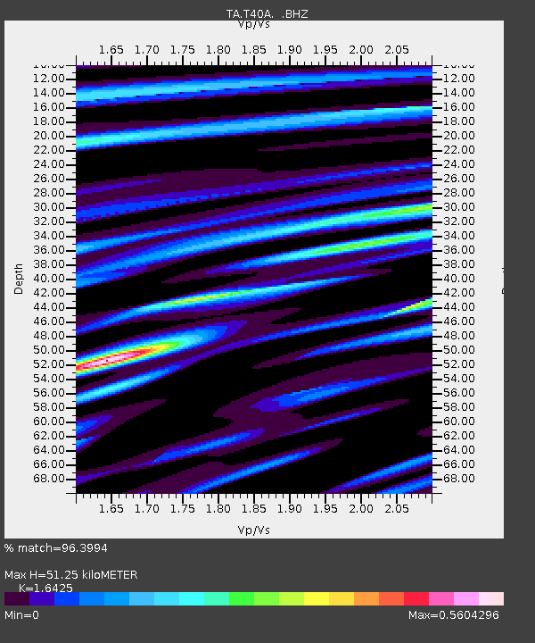
T40A Mansfield, MO, USA - Earthquake Result Viewer
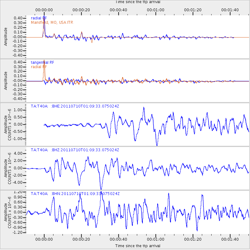
Earthquake location: Off East Coast Of Honshu, Japan
Earthquake latitude/longitude: 38.0/143.3
Earthquake time(UTC): 2011/07/10 (191) 00:57:10 GMT
Earthquake Depth: 23 km
Earthquake Magnitude: 6.6 MB, 7.0 MS, 7.0 MW, 7.0 MW
Earthquake Catalog/Contributor: WHDF/NEIC
Network: TA USArray Transportable Network (new EarthScope stations)
Station: T40A Mansfield, MO, USA
Lat/Lon: 37.15 N/92.52 W
Elevation: 399 m
Distance: 89.2 deg
Az: 41.359 deg
Baz: 319.229 deg
Ray Param: 0.042009972
Estimated Moho Depth: 51.25 km
Estimated Crust Vp/Vs: 1.64
Assumed Crust Vp: 6.53 km/s
Estimated Crust Vs: 3.976 km/s
Estimated Crust Poisson's Ratio: 0.21
Radial Match: 96.3994 %
Radial Bump: 400
Transverse Match: 87.19715 %
Transverse Bump: 400
SOD ConfigId: 395004
Insert Time: 2011-12-16 06:59:31.652 +0000
GWidth: 2.5
Max Bumps: 400
Tol: 0.001

Signal To Noise

ChannelStoNSTALTA
TA:T40A: :BHZ:20110710T01:09:33.075024Z11.5451541.1339464E-69.8218386E-8
TA:T40A: :BHN:20110710T01:09:33.075024Z3.75847553.126614E-78.318836E-8
TA:T40A: :BHE:20110710T01:09:33.075024Z4.47413832.3642284E-75.2842093E-8
Arrivals
Ps5.2 SECOND
PpPs20 SECOND
PsPs/PpSs25 SECOND