You are here: Home > Network List > TA - USArray Transportable Network (new EarthScope stations) Stations List
> Station W40A Ferguson Farm, Pottsville, AR, USA > Earthquake Result Viewer
W40A Ferguson Farm, Pottsville, AR, USA - Earthquake Result Viewer
| Earthquake location: |
Off East Coast Of Honshu, Japan |
| Earthquake latitude/longitude: |
38.0/143.3 |
| Earthquake time(UTC): |
2011/07/10 (191) 00:57:10 GMT |
| Earthquake Depth: |
23 km |
| Earthquake Magnitude: |
6.6 MB, 7.0 MS, 7.0 MW, 7.0 MW |
| Earthquake Catalog/Contributor: |
WHDF/NEIC |
|
| Network: |
TA USArray Transportable Network (new EarthScope stations) |
| Station: |
W40A Ferguson Farm, Pottsville, AR, USA |
| Lat/Lon: |
35.19 N/93.07 W |
| Elevation: |
108 m |
|
| Distance: |
90.4 deg |
| Az: |
42.975 deg |
| Baz: |
318.912 deg |
| Ray Param: |
0.04167585 |
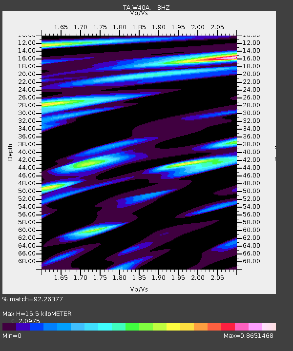
| Estimated Moho Depth: |
15.5 km |
| Estimated Crust Vp/Vs: |
2.10 |
| Assumed Crust Vp: |
6.498 km/s |
| Estimated Crust Vs: |
3.098 km/s |
| Estimated Crust Poisson's Ratio: |
0.35 |
|
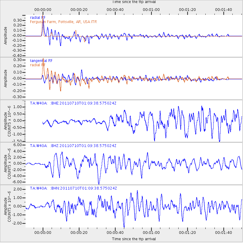
| Radial Match: |
92.26377 % |
| Radial Bump: |
400 |
| Transverse Match: |
83.32515 % |
| Transverse Bump: |
400 |
| SOD ConfigId: |
395004 |
| Insert Time: |
2011-12-16 06:59:46.758 +0000 |
| GWidth: |
2.5 |
| Max Bumps: |
400 |
| Tol: |
0.001 |
|
Signal To Noise
| Channel | StoN | STA | LTA |
| TA:W40A: :BHZ:20110710T01:09:38.575024Z | 5.311104 | 8.580689E-7 | 1.6156132E-7 |
| TA:W40A: :BHN:20110710T01:09:38.575024Z | 1.9072356 | 3.2365506E-7 | 1.6969851E-7 |
| TA:W40A: :BHE:20110710T01:09:38.575024Z | 0.67347485 | 7.766763E-8 | 1.1532373E-7 |
| Arrivals |
| Ps | 2.7 SECOND |
| PpPs | 7.3 SECOND |
| PsPs/PpSs | 9.9 SECOND |


