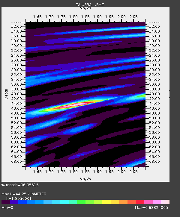
U39A Green Forest, AR, USA - Earthquake Result Viewer

Earthquake location: Off East Coast Of Honshu, Japan
Earthquake latitude/longitude: 38.0/143.3
Earthquake time(UTC): 2011/07/10 (191) 00:57:10 GMT
Earthquake Depth: 23 km
Earthquake Magnitude: 6.6 MB, 7.0 MS, 7.0 MW, 7.0 MW
Earthquake Catalog/Contributor: WHDF/NEIC
Network: TA USArray Transportable Network (new EarthScope stations)
Station: U39A Green Forest, AR, USA
Lat/Lon: 36.38 N/93.48 W
Elevation: 433 m
Distance: 89.3 deg
Az: 42.444 deg
Baz: 318.671 deg
Ray Param: 0.041958068
Estimated Moho Depth: 44.25 km
Estimated Crust Vp/Vs: 1.81
Assumed Crust Vp: 6.53 km/s
Estimated Crust Vs: 3.618 km/s
Estimated Crust Poisson's Ratio: 0.28
Radial Match: 96.85515 %
Radial Bump: 276
Transverse Match: 89.76893 %
Transverse Bump: 400
SOD ConfigId: 395004
Insert Time: 2011-12-16 07:00:22.337 +0000
GWidth: 2.5
Max Bumps: 400
Tol: 0.001

Signal To Noise

ChannelStoNSTALTA
TA:U39A: :BHZ:20110710T01:09:33.425Z18.9136241.2532981E-66.6264306E-8
TA:U39A: :BHN:20110710T01:09:33.425Z4.876463.2817314E-76.729741E-8
TA:U39A: :BHE:20110710T01:09:33.425Z4.5802192.6093224E-75.6969384E-8
Arrivals
Ps5.6 SECOND
PpPs19 SECOND
PsPs/PpSs24 SECOND