You are here: Home > Network List > G - GEOSCOPE Stations List
> Station CAN Canberra, Australia > Earthquake Result Viewer
CAN Canberra, Australia - Earthquake Result Viewer
| Earthquake location: |
Hokkaido, Japan Region |
| Earthquake latitude/longitude: |
43.4/143.3 |
| Earthquake time(UTC): |
1993/01/15 (015) 11:06:05 GMT |
| Earthquake Depth: |
100 km |
| Earthquake Magnitude: |
6.9 MB, 7.1 MS |
| Earthquake Catalog/Contributor: |
WHDF/NEIC |
|
| Network: |
G GEOSCOPE |
| Station: |
CAN Canberra, Australia |
| Lat/Lon: |
35.32 S/149.00 E |
| Elevation: |
650 m |
|
| Distance: |
78.5 deg |
| Az: |
175.213 deg |
| Baz: |
355.734 deg |
| Ray Param: |
0.04935725 |
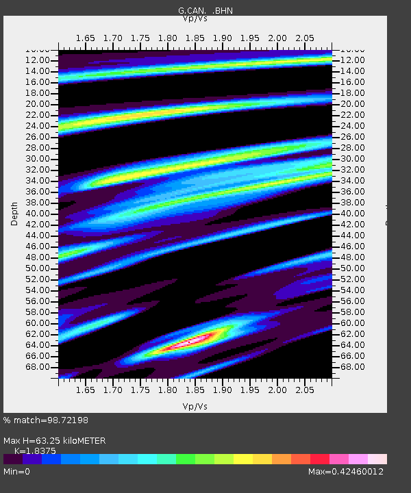
| Estimated Moho Depth: |
63.25 km |
| Estimated Crust Vp/Vs: |
1.84 |
| Assumed Crust Vp: |
6.633 km/s |
| Estimated Crust Vs: |
3.61 km/s |
| Estimated Crust Poisson's Ratio: |
0.29 |
|
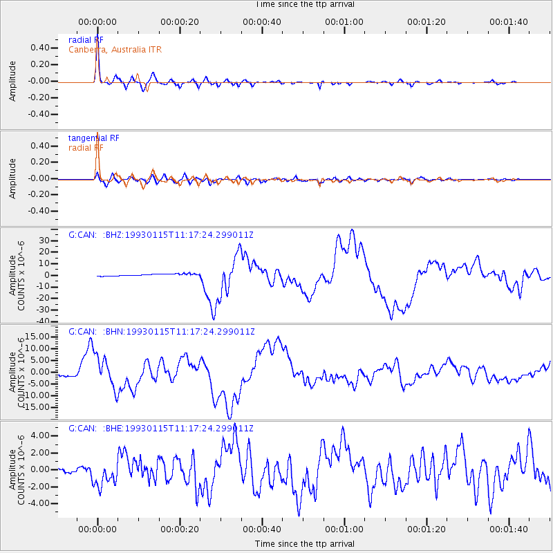
| Radial Match: |
98.72198 % |
| Radial Bump: |
326 |
| Transverse Match: |
89.023026 % |
| Transverse Bump: |
400 |
| SOD ConfigId: |
16938 |
| Insert Time: |
2010-02-26 21:38:46.991 +0000 |
| GWidth: |
2.5 |
| Max Bumps: |
400 |
| Tol: |
0.001 |
|
Signal To Noise
| Channel | StoN | STA | LTA |
| G:CAN: :BHN:19930115T11:17:24.299011Z | 15.55469 | 6.727006E-6 | 4.3247445E-7 |
| G:CAN: :BHE:19930115T11:17:24.299011Z | 7.772495 | 1.4853673E-6 | 1.911056E-7 |
| G:CAN: :BHZ:19930115T11:17:24.299011Z | 20.47515 | 1.6788763E-5 | 8.199581E-7 |
| Arrivals |
| Ps | 8.2 SECOND |
| PpPs | 26 SECOND |
| PsPs/PpSs | 34 SECOND |


