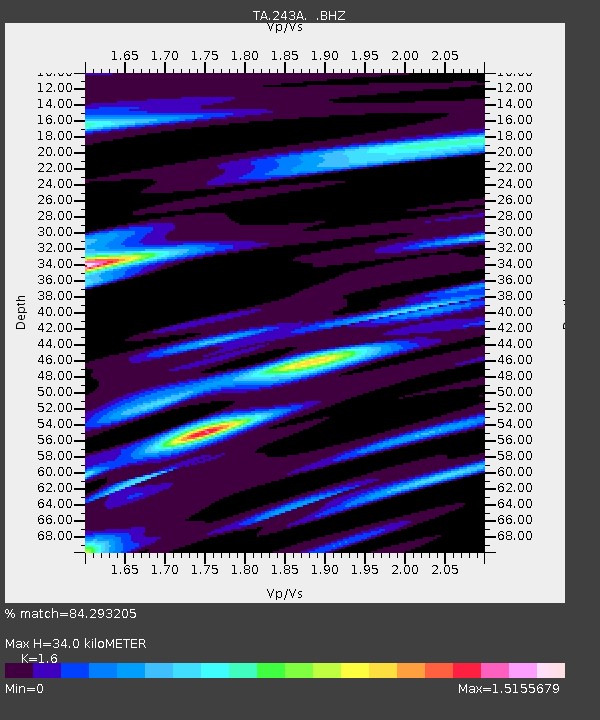
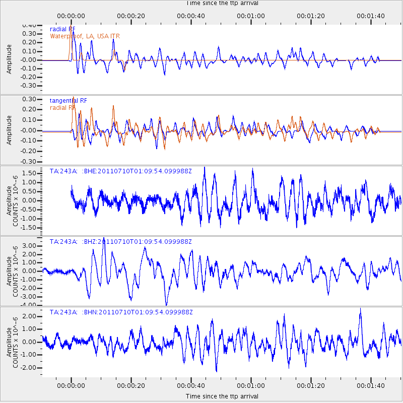
243A Waterproof, LA, USA - Earthquake Result Viewer

Earthquake location: Off East Coast Of Honshu, Japan
Earthquake latitude/longitude: 38.0/143.3
Earthquake time(UTC): 2011/07/10 (191) 00:57:10 GMT
Earthquake Depth: 23 km
Earthquake Magnitude: 6.6 MB, 7.0 MS, 7.0 MW, 7.0 MW
Earthquake Catalog/Contributor: WHDF/NEIC
Network: TA USArray Transportable Network (new EarthScope stations)
Station: 243A Waterproof, LA, USA
Lat/Lon: 31.88 N/91.48 W
Elevation: 2.0 m
Distance: 93.7 deg
Az: 44.123 deg
Baz: 319.743 deg
Ray Param: 0.041194677
Estimated Moho Depth: 34.0 km
Estimated Crust Vp/Vs: 1.60
Assumed Crust Vp: 6.065 km/s
Estimated Crust Vs: 3.79 km/s
Estimated Crust Poisson's Ratio: 0.18
Radial Match: 84.293205 %
Radial Bump: 400
Transverse Match: 77.69472 %
Transverse Bump: 400
SOD ConfigId: 395004
Insert Time: 2011-12-16 07:02:18.783 +0000
GWidth: 2.5
Max Bumps: 400
Tol: 0.001

Signal To Noise

ChannelStoNSTALTA
TA:243A: :BHZ:20110710T01:09:54.099988Z2.33719044.2455775E-71.8165305E-7
TA:243A: :BHN:20110710T01:09:54.099988Z1.15761412.7004003E-72.3327293E-7
TA:243A: :BHE:20110710T01:09:54.099988Z0.82847942.663654E-73.2151118E-7
Arrivals
Ps3.4 SECOND
PpPs14 SECOND
PsPs/PpSs18 SECOND