You are here: Home > Network List > TA - USArray Transportable Network (new EarthScope stations) Stations List
> Station 342A Flagon Creek Properties, Pineville, LA, USA > Earthquake Result Viewer
342A Flagon Creek Properties, Pineville, LA, USA - Earthquake Result Viewer
| Earthquake location: |
Off East Coast Of Honshu, Japan |
| Earthquake latitude/longitude: |
38.0/143.3 |
| Earthquake time(UTC): |
2011/07/10 (191) 00:57:10 GMT |
| Earthquake Depth: |
23 km |
| Earthquake Magnitude: |
6.6 MB, 7.0 MS, 7.0 MW, 7.0 MW |
| Earthquake Catalog/Contributor: |
WHDF/NEIC |
|
| Network: |
TA USArray Transportable Network (new EarthScope stations) |
| Station: |
342A Flagon Creek Properties, Pineville, LA, USA |
| Lat/Lon: |
31.37 N/92.32 W |
| Elevation: |
37 m |
|
| Distance: |
93.7 deg |
| Az: |
44.999 deg |
| Baz: |
319.247 deg |
| Ray Param: |
0.04121116 |
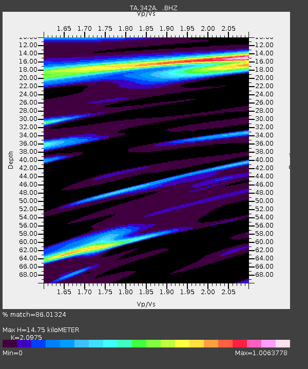
| Estimated Moho Depth: |
14.75 km |
| Estimated Crust Vp/Vs: |
2.10 |
| Assumed Crust Vp: |
6.065 km/s |
| Estimated Crust Vs: |
2.891 km/s |
| Estimated Crust Poisson's Ratio: |
0.35 |
|
| Radial Match: |
86.01324 % |
| Radial Bump: |
400 |
| Transverse Match: |
78.98292 % |
| Transverse Bump: |
400 |
| SOD ConfigId: |
395004 |
| Insert Time: |
2011-12-16 07:02:35.439 +0000 |
| GWidth: |
2.5 |
| Max Bumps: |
400 |
| Tol: |
0.001 |
|

Signal To Noise
| Channel | StoN | STA | LTA |
| TA:342A: :BHZ:20110710T01:09:53.700024Z | 2.7061362 | 3.9018371E-7 | 1.441848E-7 |
| TA:342A: :BHN:20110710T01:09:53.700024Z | 1.1383919 | 2.0017706E-7 | 1.7584196E-7 |
| TA:342A: :BHE:20110710T01:09:53.700024Z | 0.72178614 | 1.5814197E-7 | 2.190981E-7 |
| Arrivals |
| Ps | 2.7 SECOND |
| PpPs | 7.4 SECOND |
| PsPs/PpSs | 10 SECOND |


