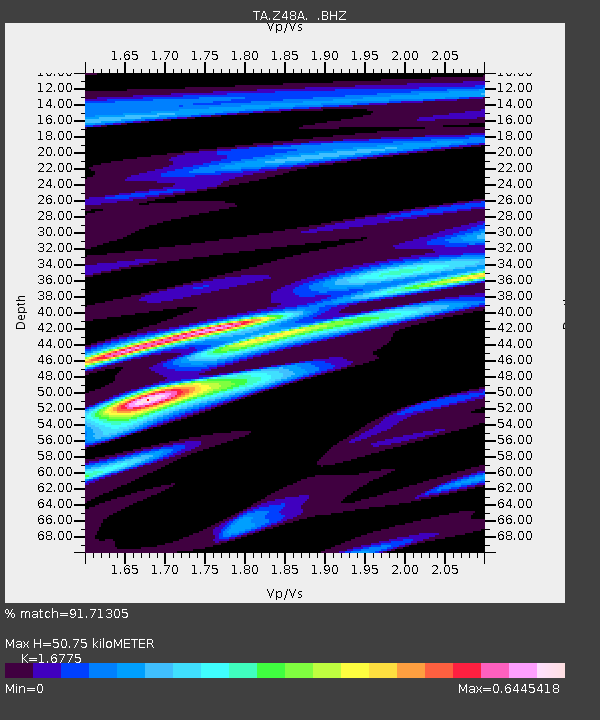
Z48A Northport, AL, USA - Earthquake Result Viewer

Earthquake location: Off East Coast Of Honshu, Japan
Earthquake latitude/longitude: 38.0/143.3
Earthquake time(UTC): 2011/07/10 (191) 00:57:10 GMT
Earthquake Depth: 23 km
Earthquake Magnitude: 6.6 MB, 7.0 MS, 7.0 MW, 7.0 MW
Earthquake Catalog/Contributor: WHDF/NEIC
Network: TA USArray Transportable Network (new EarthScope stations)
Station: Z48A Northport, AL, USA
Lat/Lon: 33.38 N/87.56 W
Elevation: 101 m
Distance: 94.7 deg
Az: 40.601 deg
Baz: 322.11 deg
Ray Param: 0.04097751
Estimated Moho Depth: 50.75 km
Estimated Crust Vp/Vs: 1.68
Assumed Crust Vp: 6.565 km/s
Estimated Crust Vs: 3.913 km/s
Estimated Crust Poisson's Ratio: 0.22
Radial Match: 91.71305 %
Radial Bump: 320
Transverse Match: 76.04092 %
Transverse Bump: 400
SOD ConfigId: 395004
Insert Time: 2011-12-16 07:05:33.822 +0000
GWidth: 2.5
Max Bumps: 400
Tol: 0.001

Signal To Noise

ChannelStoNSTALTA
TA:Z48A: :BHZ:20110710T01:09:58.349988Z7.81602246.4930174E-78.3073175E-8
TA:Z48A: :BHN:20110710T01:09:58.349988Z1.69515541.3467239E-77.944545E-8
TA:Z48A: :BHE:20110710T01:09:58.349988Z2.28070331.5854253E-76.9514755E-8
Arrivals
Ps5.4 SECOND
PpPs20 SECOND
PsPs/PpSs26 SECOND