You are here: Home > Network List > TA - USArray Transportable Network (new EarthScope stations) Stations List
> Station Q44A Meyer Farm, Vandalia, IL, USA > Earthquake Result Viewer
Q44A Meyer Farm, Vandalia, IL, USA - Earthquake Result Viewer
| Earthquake location: |
Off East Coast Of Honshu, Japan |
| Earthquake latitude/longitude: |
38.0/143.3 |
| Earthquake time(UTC): |
2011/07/10 (191) 00:57:10 GMT |
| Earthquake Depth: |
23 km |
| Earthquake Magnitude: |
6.6 MB, 7.0 MS, 7.0 MW, 7.0 MW |
| Earthquake Catalog/Contributor: |
WHDF/NEIC |
|
| Network: |
TA USArray Transportable Network (new EarthScope stations) |
| Station: |
Q44A Meyer Farm, Vandalia, IL, USA |
| Lat/Lon: |
38.90 N/89.02 W |
| Elevation: |
164 m |
|
| Distance: |
89.6 deg |
| Az: |
38.113 deg |
| Baz: |
321.344 deg |
| Ray Param: |
0.041730277 |
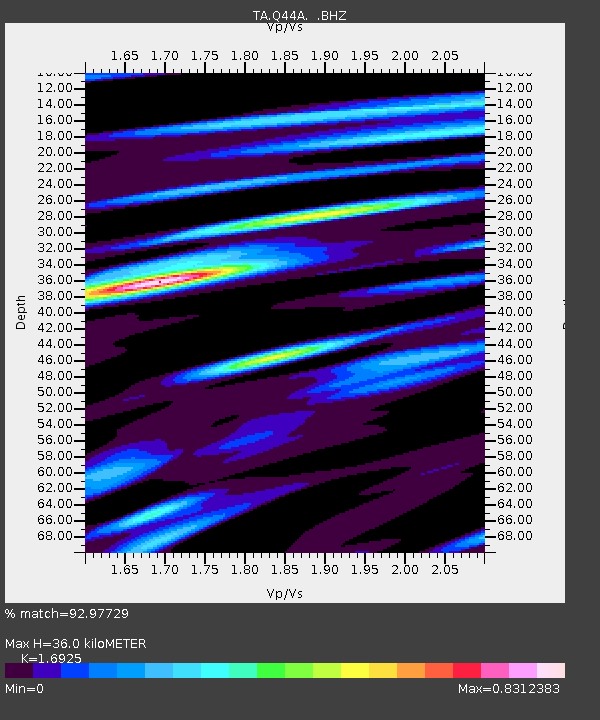
| Estimated Moho Depth: |
36.0 km |
| Estimated Crust Vp/Vs: |
1.69 |
| Assumed Crust Vp: |
6.444 km/s |
| Estimated Crust Vs: |
3.807 km/s |
| Estimated Crust Poisson's Ratio: |
0.23 |
|
| Radial Match: |
92.97729 % |
| Radial Bump: |
400 |
| Transverse Match: |
78.02469 % |
| Transverse Bump: |
400 |
| SOD ConfigId: |
395004 |
| Insert Time: |
2011-12-16 07:07:49.060 +0000 |
| GWidth: |
2.5 |
| Max Bumps: |
400 |
| Tol: |
0.001 |
|
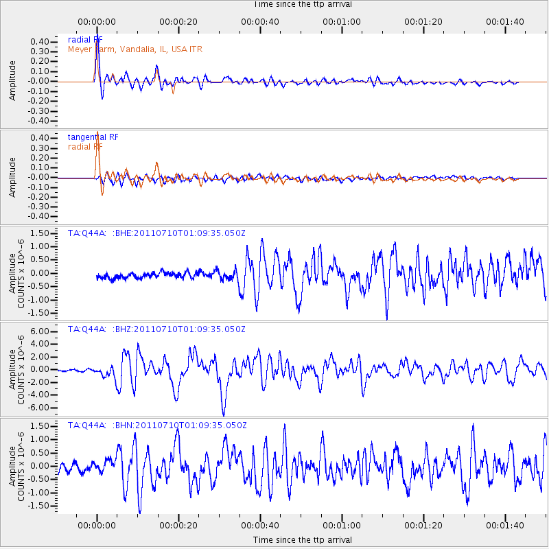
Signal To Noise
| Channel | StoN | STA | LTA |
| TA:Q44A: :BHZ:20110710T01:09:35.050Z | 9.220619 | 8.817144E-7 | 9.56242E-8 |
| TA:Q44A: :BHN:20110710T01:09:35.050Z | 1.3111291 | 1.9608211E-7 | 1.495521E-7 |
| TA:Q44A: :BHE:20110710T01:09:35.050Z | 1.8582615 | 1.8818555E-7 | 1.0126968E-7 |
| Arrivals |
| Ps | 4.0 SECOND |
| PpPs | 15 SECOND |
| PsPs/PpSs | 19 SECOND |


