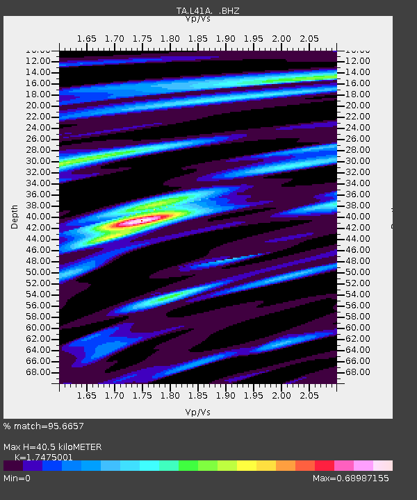
L41A Preston, IA, USA - Earthquake Result Viewer

Earthquake location: Off East Coast Of Honshu, Japan
Earthquake latitude/longitude: 38.0/143.3
Earthquake time(UTC): 2011/07/10 (191) 00:57:10 GMT
Earthquake Depth: 23 km
Earthquake Magnitude: 6.6 MB, 7.0 MS, 7.0 MW, 7.0 MW
Earthquake Catalog/Contributor: WHDF/NEIC
Network: TA USArray Transportable Network (new EarthScope stations)
Station: L41A Preston, IA, USA
Lat/Lon: 42.08 N/90.50 W
Elevation: 238 m
Distance: 86.4 deg
Az: 36.988 deg
Baz: 320.347 deg
Ray Param: 0.04402801
Estimated Moho Depth: 40.5 km
Estimated Crust Vp/Vs: 1.75
Assumed Crust Vp: 6.53 km/s
Estimated Crust Vs: 3.737 km/s
Estimated Crust Poisson's Ratio: 0.26
Radial Match: 95.6657 %
Radial Bump: 400
Transverse Match: 86.61479 %
Transverse Bump: 400
SOD ConfigId: 395004
Insert Time: 2011-12-16 07:08:05.087 +0000
GWidth: 2.5
Max Bumps: 400
Tol: 0.001

Signal To Noise

ChannelStoNSTALTA
TA:L41A: :BHZ:20110710T01:09:19.974988Z18.5372261.8761584E-61.0121032E-7
TA:L41A: :BHN:20110710T01:09:19.974988Z5.7318395.301222E-79.248728E-8
TA:L41A: :BHE:20110710T01:09:19.974988Z4.3630464.0363514E-79.251223E-8
Arrivals
Ps4.7 SECOND
PpPs17 SECOND
PsPs/PpSs21 SECOND