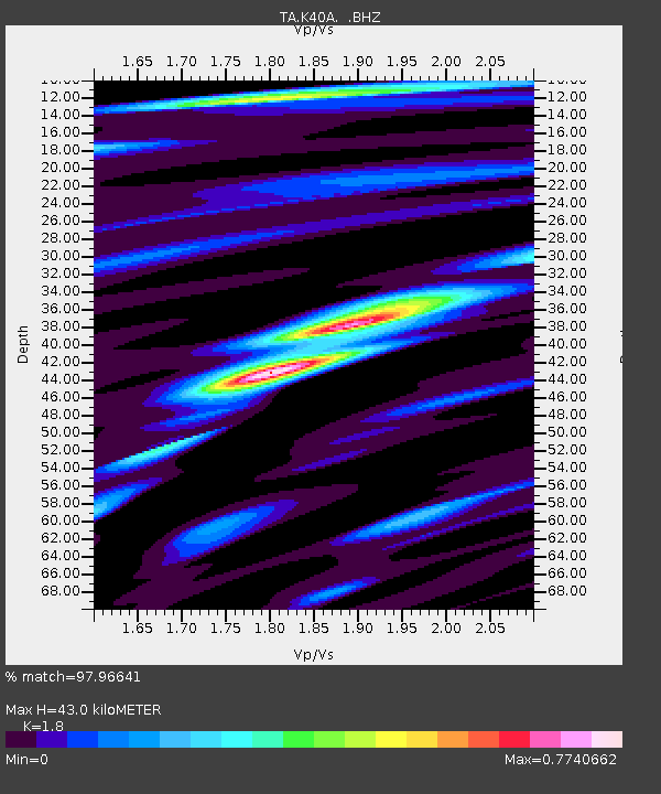
K40A Colesburg, IA, USA - Earthquake Result Viewer

Earthquake location: Off East Coast Of Honshu, Japan
Earthquake latitude/longitude: 38.0/143.3
Earthquake time(UTC): 2011/07/10 (191) 00:57:10 GMT
Earthquake Depth: 23 km
Earthquake Magnitude: 6.6 MB, 7.0 MS, 7.0 MW, 7.0 MW
Earthquake Catalog/Contributor: WHDF/NEIC
Network: TA USArray Transportable Network (new EarthScope stations)
Station: K40A Colesburg, IA, USA
Lat/Lon: 42.70 N/91.14 W
Elevation: 274 m
Distance: 85.7 deg
Az: 36.952 deg
Baz: 319.914 deg
Ray Param: 0.044584434
Estimated Moho Depth: 43.0 km
Estimated Crust Vp/Vs: 1.80
Assumed Crust Vp: 6.53 km/s
Estimated Crust Vs: 3.628 km/s
Estimated Crust Poisson's Ratio: 0.28
Radial Match: 97.96641 %
Radial Bump: 400
Transverse Match: 86.84648 %
Transverse Bump: 400
SOD ConfigId: 395004
Insert Time: 2011-12-16 07:08:12.679 +0000
GWidth: 2.5
Max Bumps: 400
Tol: 0.001

Signal To Noise

ChannelStoNSTALTA
TA:K40A: :BHZ:20110710T01:09:16.099988Z25.2125571.8159079E-67.202395E-8
TA:K40A: :BHN:20110710T01:09:16.099988Z5.54257975.4434753E-79.821194E-8
TA:K40A: :BHE:20110710T01:09:16.099988Z6.81820064.39857E-76.451218E-8
Arrivals
Ps5.4 SECOND
PpPs18 SECOND
PsPs/PpSs23 SECOND