You are here: Home > Network List > G - GEOSCOPE Stations List
> Station CAN Canberra, Australia > Earthquake Result Viewer
CAN Canberra, Australia - Earthquake Result Viewer
| Earthquake location: |
Banda Sea |
| Earthquake latitude/longitude: |
-7.2/128.6 |
| Earthquake time(UTC): |
1993/01/20 (020) 17:31:15 GMT |
| Earthquake Depth: |
33 km |
| Earthquake Magnitude: |
6.0 MB, 6.3 MS |
| Earthquake Catalog/Contributor: |
WHDF/NEIC |
|
| Network: |
G GEOSCOPE |
| Station: |
CAN Canberra, Australia |
| Lat/Lon: |
35.32 S/149.00 E |
| Elevation: |
650 m |
|
| Distance: |
33.6 deg |
| Az: |
149.035 deg |
| Baz: |
321.374 deg |
| Ray Param: |
0.078056864 |
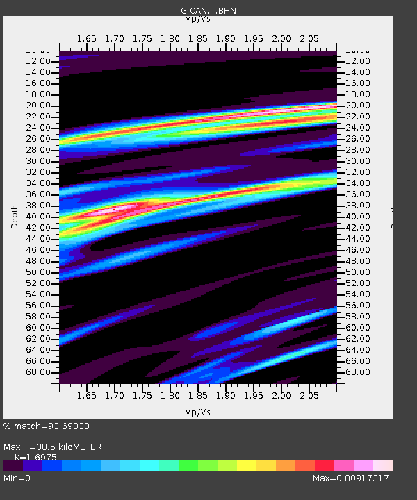
| Estimated Moho Depth: |
38.5 km |
| Estimated Crust Vp/Vs: |
1.70 |
| Assumed Crust Vp: |
6.633 km/s |
| Estimated Crust Vs: |
3.908 km/s |
| Estimated Crust Poisson's Ratio: |
0.23 |
|
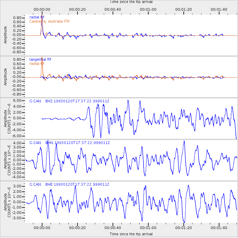
| Radial Match: |
93.69833 % |
| Radial Bump: |
246 |
| Transverse Match: |
64.26419 % |
| Transverse Bump: |
400 |
| SOD ConfigId: |
16938 |
| Insert Time: |
2010-02-26 21:38:56.145 +0000 |
| GWidth: |
2.5 |
| Max Bumps: |
400 |
| Tol: |
0.001 |
|
Signal To Noise
| Channel | StoN | STA | LTA |
| G:CAN: :BHN:19930120T17:37:22.999011Z | 19.957462 | 2.5616955E-6 | 1.2835777E-7 |
| G:CAN: :BHE:19930120T17:37:22.999011Z | 11.267049 | 1.5944963E-6 | 1.4151854E-7 |
| G:CAN: :BHZ:19930120T17:37:22.999011Z | 19.943253 | 4.1212666E-6 | 2.0664967E-7 |
| Arrivals |
| Ps | 4.4 SECOND |
| PpPs | 14 SECOND |
| PsPs/PpSs | 19 SECOND |


