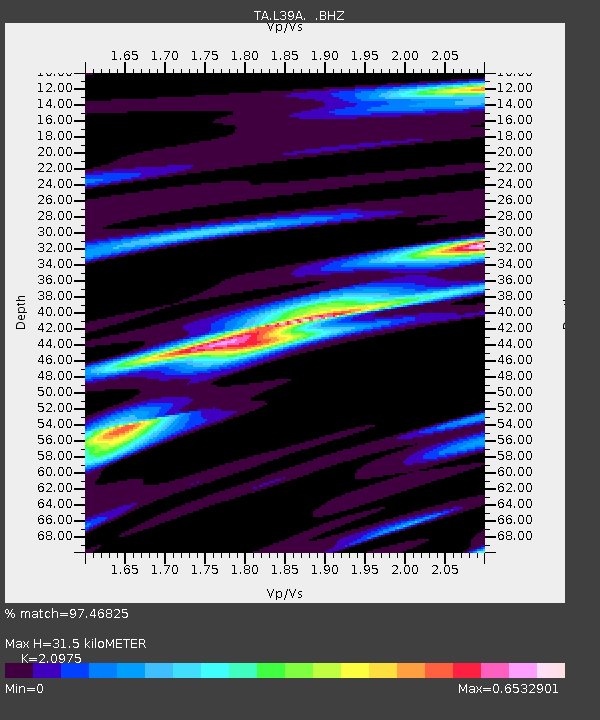
L39A Vinton, IA, USA - Earthquake Result Viewer
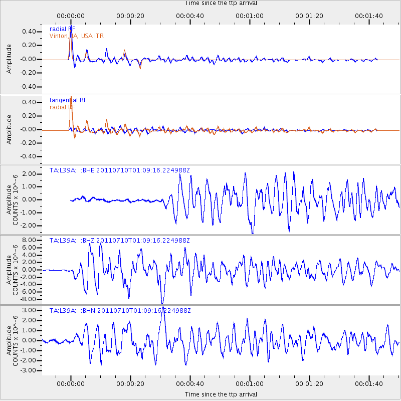
Earthquake location: Off East Coast Of Honshu, Japan
Earthquake latitude/longitude: 38.0/143.3
Earthquake time(UTC): 2011/07/10 (191) 00:57:10 GMT
Earthquake Depth: 23 km
Earthquake Magnitude: 6.6 MB, 7.0 MS, 7.0 MW, 7.0 MW
Earthquake Catalog/Contributor: WHDF/NEIC
Network: TA USArray Transportable Network (new EarthScope stations)
Station: L39A Vinton, IA, USA
Lat/Lon: 42.12 N/92.00 W
Elevation: 261 m
Distance: 85.7 deg
Az: 37.814 deg
Baz: 319.4 deg
Ray Param: 0.044566046
Estimated Moho Depth: 31.5 km
Estimated Crust Vp/Vs: 2.10
Assumed Crust Vp: 6.53 km/s
Estimated Crust Vs: 3.113 km/s
Estimated Crust Poisson's Ratio: 0.35
Radial Match: 97.46825 %
Radial Bump: 315
Transverse Match: 87.07084 %
Transverse Bump: 400
SOD ConfigId: 395004
Insert Time: 2011-12-16 07:08:33.635 +0000
GWidth: 2.5
Max Bumps: 400
Tol: 0.001

Signal To Noise

ChannelStoNSTALTA
TA:L39A: :BHZ:20110710T01:09:16.224988Z16.2530331.9944957E-61.227153E-7
TA:L39A: :BHN:20110710T01:09:16.224988Z5.65543034.8378536E-78.5543505E-8
TA:L39A: :BHE:20110710T01:09:16.224988Z4.4406784.248346E-79.566886E-8
Arrivals
Ps5.4 SECOND
PpPs15 SECOND
PsPs/PpSs20 SECOND