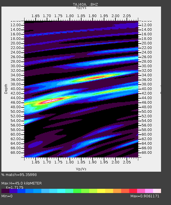
J40A Soldiers Grove, WI, USA - Earthquake Result Viewer
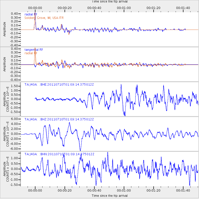
Earthquake location: Off East Coast Of Honshu, Japan
Earthquake latitude/longitude: 38.0/143.3
Earthquake time(UTC): 2011/07/10 (191) 00:57:10 GMT
Earthquake Depth: 23 km
Earthquake Magnitude: 6.6 MB, 7.0 MS, 7.0 MW, 7.0 MW
Earthquake Catalog/Contributor: WHDF/NEIC
Network: TA USArray Transportable Network (new EarthScope stations)
Station: J40A Soldiers Grove, WI, USA
Lat/Lon: 43.40 N/90.74 W
Elevation: 353 m
Distance: 85.3 deg
Az: 36.279 deg
Baz: 320.132 deg
Ray Param: 0.04483266
Estimated Moho Depth: 45.0 km
Estimated Crust Vp/Vs: 1.72
Assumed Crust Vp: 6.53 km/s
Estimated Crust Vs: 3.802 km/s
Estimated Crust Poisson's Ratio: 0.24
Radial Match: 95.35998 %
Radial Bump: 400
Transverse Match: 88.17959 %
Transverse Bump: 400
SOD ConfigId: 395004
Insert Time: 2011-12-16 07:08:50.782 +0000
GWidth: 2.5
Max Bumps: 400
Tol: 0.001

Signal To Noise

ChannelStoNSTALTA
TA:J40A: :BHZ:20110710T01:09:14.375012Z19.7972151.7514133E-68.846766E-8
TA:J40A: :BHN:20110710T01:09:14.375012Z3.86264734.1128422E-71.06477295E-7
TA:J40A: :BHE:20110710T01:09:14.375012Z5.09466463.6376048E-77.140028E-8
Arrivals
Ps5.1 SECOND
PpPs18 SECOND
PsPs/PpSs23 SECOND