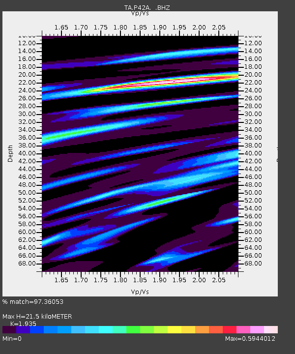
P42A Winchester, IL, USA - Earthquake Result Viewer
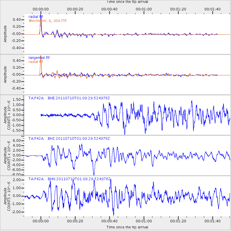
Earthquake location: Off East Coast Of Honshu, Japan
Earthquake latitude/longitude: 38.0/143.3
Earthquake time(UTC): 2011/07/10 (191) 00:57:10 GMT
Earthquake Depth: 23 km
Earthquake Magnitude: 6.6 MB, 7.0 MS, 7.0 MW, 7.0 MW
Earthquake Catalog/Contributor: WHDF/NEIC
Network: TA USArray Transportable Network (new EarthScope stations)
Station: P42A Winchester, IL, USA
Lat/Lon: 39.59 N/90.34 W
Elevation: 197 m
Distance: 88.4 deg
Az: 38.484 deg
Baz: 320.514 deg
Ray Param: 0.042568497
Estimated Moho Depth: 21.5 km
Estimated Crust Vp/Vs: 1.93
Assumed Crust Vp: 6.498 km/s
Estimated Crust Vs: 3.358 km/s
Estimated Crust Poisson's Ratio: 0.32
Radial Match: 97.36053 %
Radial Bump: 291
Transverse Match: 85.09813 %
Transverse Bump: 400
SOD ConfigId: 395004
Insert Time: 2011-12-16 07:09:06.288 +0000
GWidth: 2.5
Max Bumps: 400
Tol: 0.001

Signal To Noise

ChannelStoNSTALTA
TA:P42A: :BHZ:20110710T01:09:29.524976Z13.9403651.2389106E-68.887218E-8
TA:P42A: :BHN:20110710T01:09:29.524976Z4.73489244.4567156E-79.4124964E-8
TA:P42A: :BHE:20110710T01:09:29.524976Z5.21054743.2321168E-76.203027E-8
Arrivals
Ps3.2 SECOND
PpPs9.5 SECOND
PsPs/PpSs13 SECOND