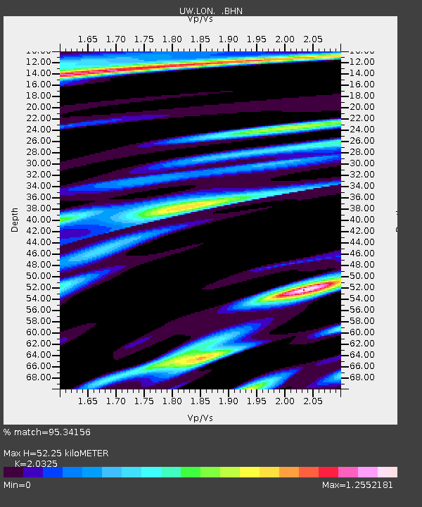
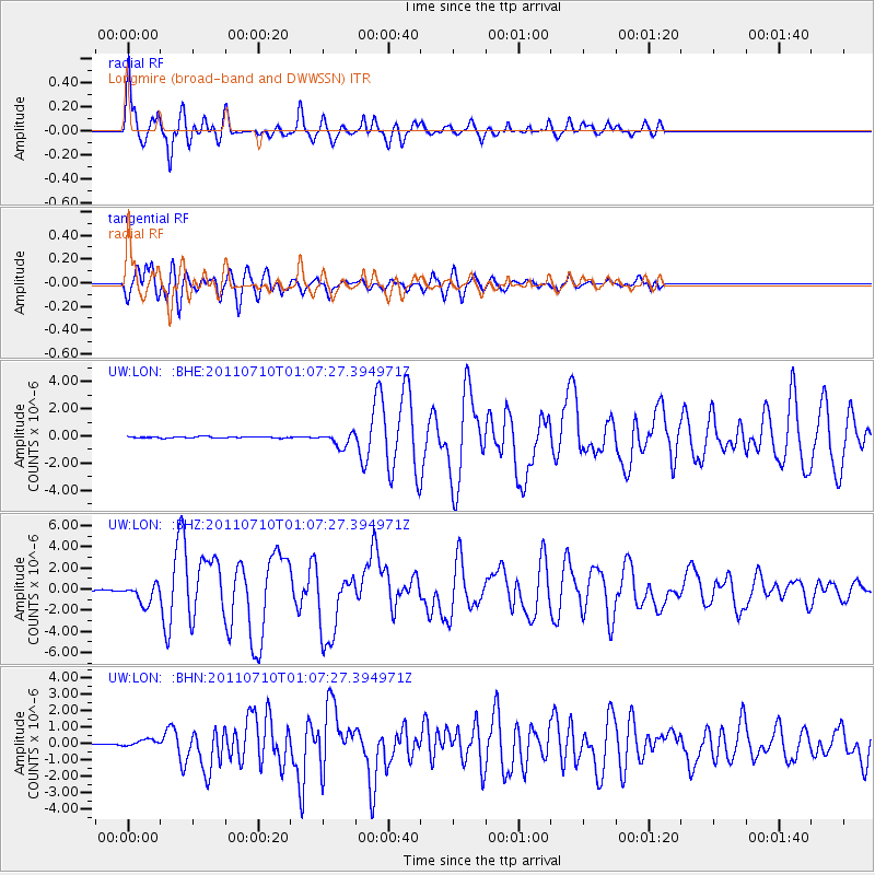
LON Longmire (broad-band and DWWSSN) - Earthquake Result Viewer

Earthquake location: Off East Coast Of Honshu, Japan
Earthquake latitude/longitude: 38.0/143.3
Earthquake time(UTC): 2011/07/10 (191) 00:57:10 GMT
Earthquake Depth: 23 km
Earthquake Magnitude: 6.6 MB, 7.0 MS, 7.0 MW, 7.0 MW
Earthquake Catalog/Contributor: WHDF/NEIC
Network: UW Pacific Northwest Regional Seismic Network
Station: LON Longmire (broad-band and DWWSSN)
Lat/Lon: 46.75 N/121.81 W
Elevation: 850 m
Distance: 66.5 deg
Az: 48.338 deg
Baz: 300.915 deg
Ray Param: 0.057551865
Estimated Moho Depth: 52.25 km
Estimated Crust Vp/Vs: 2.03
Assumed Crust Vp: 6.597 km/s
Estimated Crust Vs: 3.246 km/s
Estimated Crust Poisson's Ratio: 0.34
Radial Match: 95.34156 %
Radial Bump: 400
Transverse Match: 85.648125 %
Transverse Bump: 400
SOD ConfigId: 395004
Insert Time: 2011-12-16 07:11:06.356 +0000
GWidth: 2.5
Max Bumps: 400
Tol: 0.001

Signal To Noise

ChannelStoNSTALTA
UW:LON: :BHZ:20110710T01:07:27.394971Z21.5232739.257029E-74.300939E-8
UW:LON: :BHN:20110710T01:07:27.394971Z5.0403632.1653466E-74.2960135E-8
UW:LON: :BHE:20110710T01:07:27.394971Z9.7663465.058502E-75.1795237E-8
Arrivals
Ps8.5 SECOND
PpPs23 SECOND
PsPs/PpSs32 SECOND