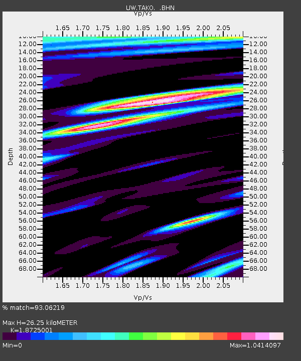
TAKO Tahkenitch, OR CREST BB SMO - Earthquake Result Viewer

Earthquake location: Off East Coast Of Honshu, Japan
Earthquake latitude/longitude: 38.0/143.3
Earthquake time(UTC): 2011/07/10 (191) 00:57:10 GMT
Earthquake Depth: 23 km
Earthquake Magnitude: 6.6 MB, 7.0 MS, 7.0 MW, 7.0 MW
Earthquake Catalog/Contributor: WHDF/NEIC
Network: UW Pacific Northwest Regional Seismic Network
Station: TAKO Tahkenitch, OR CREST BB SMO
Lat/Lon: 43.74 N/124.08 W
Elevation: 46 m
Distance: 66.7 deg
Az: 52.048 deg
Baz: 300.781 deg
Ray Param: 0.05744313
Estimated Moho Depth: 26.25 km
Estimated Crust Vp/Vs: 1.87
Assumed Crust Vp: 6.048 km/s
Estimated Crust Vs: 3.23 km/s
Estimated Crust Poisson's Ratio: 0.30
Radial Match: 93.06219 %
Radial Bump: 400
Transverse Match: 80.34248 %
Transverse Bump: 400
SOD ConfigId: 395004
Insert Time: 2011-12-16 07:11:40.975 +0000
GWidth: 2.5
Max Bumps: 400
Tol: 0.001

Signal To Noise

ChannelStoNSTALTA
UW:TAKO: :BHZ:20110710T01:07:28.445996Z3.7942861.7257037E-64.5481644E-7
UW:TAKO: :BHN:20110710T01:07:28.445996Z1.65414235.1370665E-73.105577E-7
UW:TAKO: :BHE:20110710T01:07:28.445996Z1.44880715.5050003E-73.799678E-7
Arrivals
Ps3.9 SECOND
PpPs12 SECOND
PsPs/PpSs16 SECOND