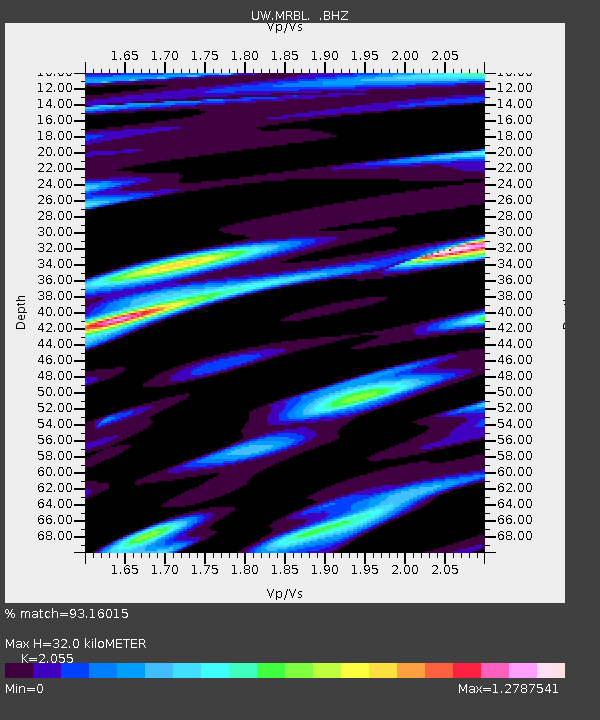
MRBL Marblemount, WA, USA - Earthquake Result Viewer
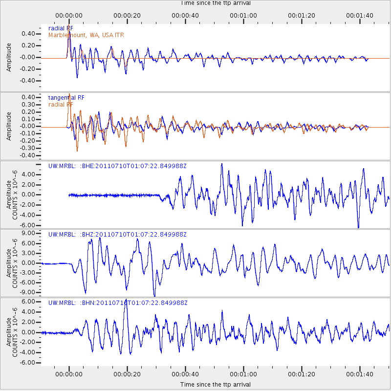
Earthquake location: Off East Coast Of Honshu, Japan
Earthquake latitude/longitude: 38.0/143.3
Earthquake time(UTC): 2011/07/10 (191) 00:57:10 GMT
Earthquake Depth: 23 km
Earthquake Magnitude: 6.6 MB, 7.0 MS, 7.0 MW, 7.0 MW
Earthquake Catalog/Contributor: WHDF/NEIC
Network: UW Pacific Northwest Regional Seismic Network
Station: MRBL Marblemount, WA, USA
Lat/Lon: 48.52 N/121.48 W
Elevation: 75 m
Distance: 65.8 deg
Az: 46.551 deg
Baz: 300.432 deg
Ray Param: 0.058019057
Estimated Moho Depth: 32.0 km
Estimated Crust Vp/Vs: 2.06
Assumed Crust Vp: 6.566 km/s
Estimated Crust Vs: 3.195 km/s
Estimated Crust Poisson's Ratio: 0.34
Radial Match: 93.16015 %
Radial Bump: 400
Transverse Match: 84.14261 %
Transverse Bump: 400
SOD ConfigId: 395004
Insert Time: 2011-12-16 07:12:09.588 +0000
GWidth: 2.5
Max Bumps: 400
Tol: 0.001

Signal To Noise

ChannelStoNSTALTA
UW:MRBL: :BHZ:20110710T01:07:22.849988Z21.2874771.5989389E-67.5111714E-8
UW:MRBL: :BHN:20110710T01:07:22.849988Z3.7131893.708173E-79.986492E-8
UW:MRBL: :BHE:20110710T01:07:22.849988Z5.96804145.721226E-79.586438E-8
Arrivals
Ps5.3 SECOND
PpPs14 SECOND
PsPs/PpSs20 SECOND