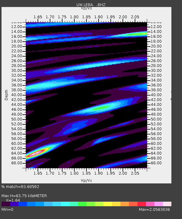
LEBA Lebam, WA, USA - Earthquake Result Viewer
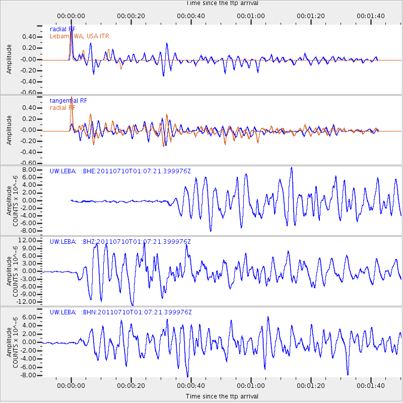
Earthquake location: Off East Coast Of Honshu, Japan
Earthquake latitude/longitude: 38.0/143.3
Earthquake time(UTC): 2011/07/10 (191) 00:57:10 GMT
Earthquake Depth: 23 km
Earthquake Magnitude: 6.6 MB, 7.0 MS, 7.0 MW, 7.0 MW
Earthquake Catalog/Contributor: WHDF/NEIC
Network: UW Pacific Northwest Regional Seismic Network
Station: LEBA Lebam, WA, USA
Lat/Lon: 46.55 N/123.56 W
Elevation: 73 m
Distance: 65.6 deg
Az: 49.201 deg
Baz: 299.995 deg
Ray Param: 0.05816632
Estimated Moho Depth: 63.75 km
Estimated Crust Vp/Vs: 1.64
Assumed Crust Vp: 6.566 km/s
Estimated Crust Vs: 4.004 km/s
Estimated Crust Poisson's Ratio: 0.20
Radial Match: 93.68592 %
Radial Bump: 400
Transverse Match: 75.681175 %
Transverse Bump: 400
SOD ConfigId: 395004
Insert Time: 2011-12-16 07:12:59.491 +0000
GWidth: 2.5
Max Bumps: 400
Tol: 0.001

Signal To Noise

ChannelStoNSTALTA
UW:LEBA: :BHZ:20110710T01:07:21.399976Z13.3159891.558898E-61.1706964E-7
UW:LEBA: :BHN:20110710T01:07:21.399976Z3.0204054.1213985E-71.3645185E-7
UW:LEBA: :BHE:20110710T01:07:21.399976Z3.19122584.5522577E-71.4264918E-7
Arrivals
Ps6.5 SECOND
PpPs24 SECOND
PsPs/PpSs31 SECOND