You are here: Home > Network List > CI - Caltech Regional Seismic Network Stations List
> Station MPM Manuel Prospect Mine, California, USA > Earthquake Result Viewer
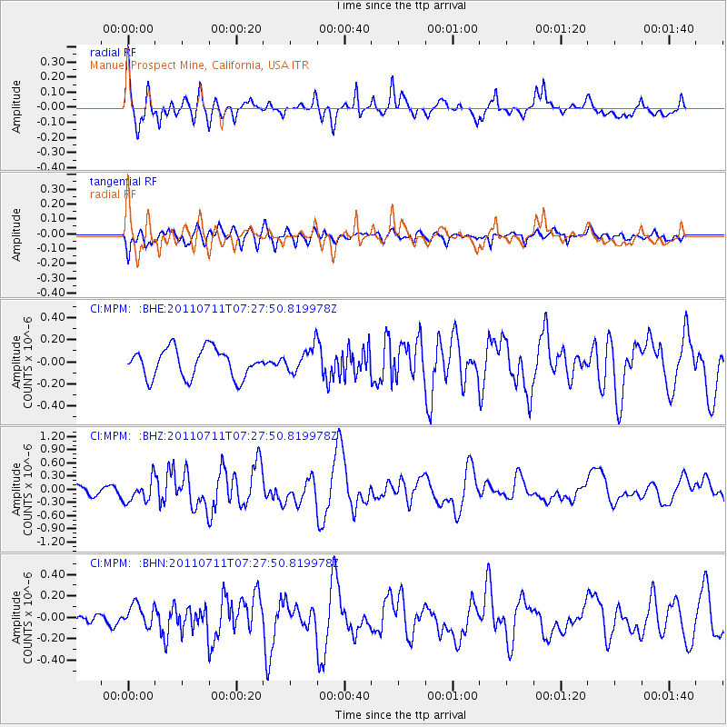
MPM Manuel Prospect Mine, California, USA - Earthquake Result Viewer
*The percent match for this event was below the threshold and hence no stack was calculated.
| Earthquake location: |
Kermadec Islands Region |
| Earthquake latitude/longitude: |
-29.5/-176.6 |
| Earthquake time(UTC): |
2011/07/11 (192) 07:15:43 GMT |
| Earthquake Depth: |
11 km |
| Earthquake Magnitude: |
5.5 MB, 6.0 MS, 6.1 MW, 5.9 MW |
| Earthquake Catalog/Contributor: |
WHDF/NEIC |
|
| Network: |
CI Caltech Regional Seismic Network |
| Station: |
MPM Manuel Prospect Mine, California, USA |
| Lat/Lon: |
36.06 N/117.49 W |
| Elevation: |
185 m |
|
| Distance: |
85.6 deg |
| Az: |
44.205 deg |
| Baz: |
228.609 deg |
| Ray Param: |
$rayparam |
*The percent match for this event was below the threshold and hence was not used in the summary stack. |
|
| Radial Match: |
71.070694 % |
| Radial Bump: |
400 |
| Transverse Match: |
72.53748 % |
| Transverse Bump: |
400 |
| SOD ConfigId: |
395004 |
| Insert Time: |
2011-12-16 07:25:50.656 +0000 |
| GWidth: |
2.5 |
| Max Bumps: |
400 |
| Tol: |
0.001 |
|
Signal To Noise
| Channel | StoN | STA | LTA |
| CI:MPM: :BHZ:20110711T07:27:50.819978Z | 1.6088598 | 2.5928446E-7 | 1.6116039E-7 |
| CI:MPM: :BHN:20110711T07:27:50.819978Z | 1.1832451 | 1.0579075E-7 | 8.94073E-8 |
| CI:MPM: :BHE:20110711T07:27:50.819978Z | 0.89775145 | 1.1660004E-7 | 1.2988009E-7 |
| Arrivals |
| Ps | |
| PpPs | |
| PsPs/PpSs | |


