You are here: Home > Network List > TA - USArray Transportable Network (new EarthScope stations) Stations List
> Station R11A Troy Canyon, Currant, NV, USA > Earthquake Result Viewer
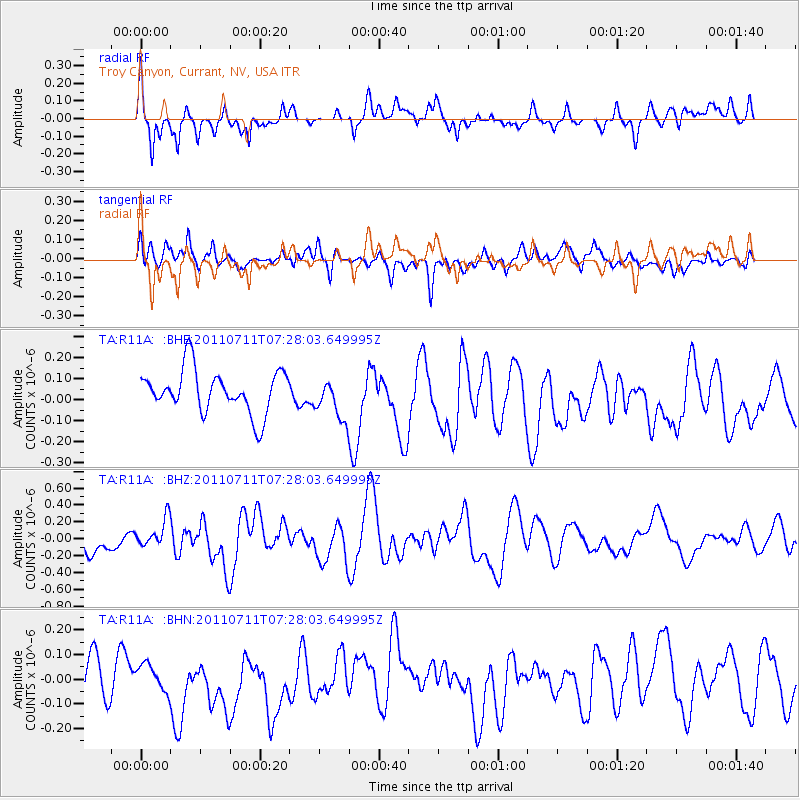
R11A Troy Canyon, Currant, NV, USA - Earthquake Result Viewer
*The percent match for this event was below the threshold and hence no stack was calculated.
| Earthquake location: |
Kermadec Islands Region |
| Earthquake latitude/longitude: |
-29.5/-176.6 |
| Earthquake time(UTC): |
2011/07/11 (192) 07:15:43 GMT |
| Earthquake Depth: |
11 km |
| Earthquake Magnitude: |
5.5 MB, 6.0 MS, 6.1 MW, 5.9 MW |
| Earthquake Catalog/Contributor: |
WHDF/NEIC |
|
| Network: |
TA USArray Transportable Network (new EarthScope stations) |
| Station: |
R11A Troy Canyon, Currant, NV, USA |
| Lat/Lon: |
38.35 N/115.59 W |
| Elevation: |
1756 m |
|
| Distance: |
88.3 deg |
| Az: |
43.468 deg |
| Baz: |
229.716 deg |
| Ray Param: |
$rayparam |
*The percent match for this event was below the threshold and hence was not used in the summary stack. |
|
| Radial Match: |
61.45398 % |
| Radial Bump: |
400 |
| Transverse Match: |
57.371395 % |
| Transverse Bump: |
400 |
| SOD ConfigId: |
395004 |
| Insert Time: |
2011-12-16 07:31:46.055 +0000 |
| GWidth: |
2.5 |
| Max Bumps: |
400 |
| Tol: |
0.001 |
|
Signal To Noise
| Channel | StoN | STA | LTA |
| TA:R11A: :BHZ:20110711T07:28:03.649995Z | 1.4010055 | 1.6989316E-7 | 1.2126516E-7 |
| TA:R11A: :BHN:20110711T07:28:03.649995Z | 0.6657635 | 7.7338896E-8 | 1.1616572E-7 |
| TA:R11A: :BHE:20110711T07:28:03.649995Z | 0.9535322 | 9.717687E-8 | 1.01912526E-7 |
| Arrivals |
| Ps | |
| PpPs | |
| PsPs/PpSs | |


