You are here: Home > Network List > CI - Caltech Regional Seismic Network Stations List
> Station MUR Murrieta > Earthquake Result Viewer
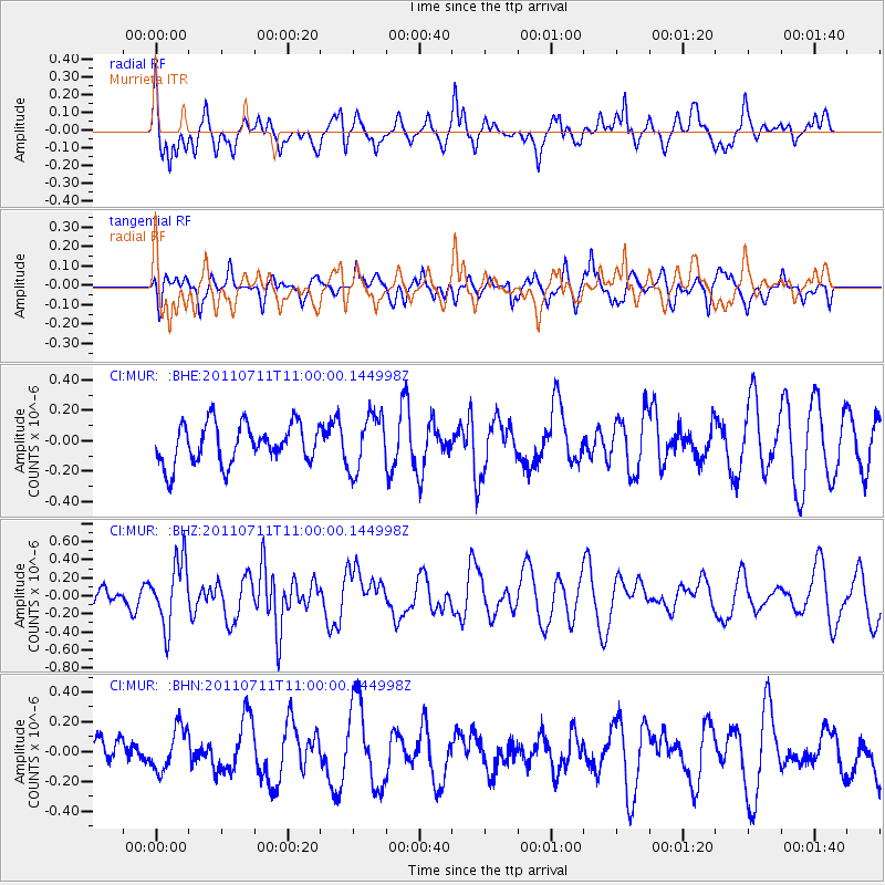
MUR Murrieta - Earthquake Result Viewer
*The percent match for this event was below the threshold and hence no stack was calculated.
| Earthquake location: |
Tonga Islands Region |
| Earthquake latitude/longitude: |
-22.7/-174.7 |
| Earthquake time(UTC): |
2011/07/11 (192) 10:48:32 GMT |
| Earthquake Depth: |
21 km |
| Earthquake Magnitude: |
5.6 MB, 5.4 MS, 5.6 MW, 5.6 MW |
| Earthquake Catalog/Contributor: |
WHDF/NEIC |
|
| Network: |
CI Caltech Regional Seismic Network |
| Station: |
MUR Murrieta |
| Lat/Lon: |
33.60 N/117.20 W |
| Elevation: |
562 m |
|
| Distance: |
78.3 deg |
| Az: |
45.989 deg |
| Baz: |
232.737 deg |
| Ray Param: |
$rayparam |
*The percent match for this event was below the threshold and hence was not used in the summary stack. |
|
| Radial Match: |
67.12556 % |
| Radial Bump: |
400 |
| Transverse Match: |
51.310703 % |
| Transverse Bump: |
397 |
| SOD ConfigId: |
395004 |
| Insert Time: |
2011-12-16 07:57:40.064 +0000 |
| GWidth: |
2.5 |
| Max Bumps: |
400 |
| Tol: |
0.001 |
|
Signal To Noise
| Channel | StoN | STA | LTA |
| CI:MUR: :BHZ:20110711T11:00:00.144998Z | 3.9152606 | 3.598544E-7 | 9.191072E-8 |
| CI:MUR: :BHN:20110711T11:00:00.144998Z | 0.7611166 | 1.4622515E-7 | 1.9211924E-7 |
| CI:MUR: :BHE:20110711T11:00:00.144998Z | 1.3999448 | 1.8310703E-7 | 1.307959E-7 |
| Arrivals |
| Ps | |
| PpPs | |
| PsPs/PpSs | |


