You are here: Home > Network List > TA - USArray Transportable Network (new EarthScope stations) Stations List
> Station K30A Basset, NE, USA > Earthquake Result Viewer
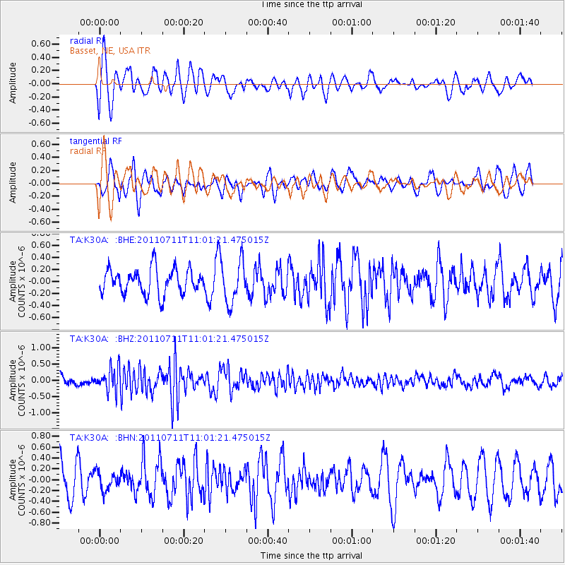
K30A Basset, NE, USA - Earthquake Result Viewer
*The percent match for this event was below the threshold and hence no stack was calculated.
| Earthquake location: |
Tonga Islands Region |
| Earthquake latitude/longitude: |
-22.7/-174.7 |
| Earthquake time(UTC): |
2011/07/11 (192) 10:48:32 GMT |
| Earthquake Depth: |
21 km |
| Earthquake Magnitude: |
5.6 MB, 5.4 MS, 5.6 MW, 5.6 MW |
| Earthquake Catalog/Contributor: |
WHDF/NEIC |
|
| Network: |
TA USArray Transportable Network (new EarthScope stations) |
| Station: |
K30A Basset, NE, USA |
| Lat/Lon: |
42.67 N/99.61 W |
| Elevation: |
712 m |
|
| Distance: |
94.8 deg |
| Az: |
45.671 deg |
| Baz: |
243.618 deg |
| Ray Param: |
$rayparam |
*The percent match for this event was below the threshold and hence was not used in the summary stack. |
|
| Radial Match: |
65.12794 % |
| Radial Bump: |
400 |
| Transverse Match: |
72.59444 % |
| Transverse Bump: |
400 |
| SOD ConfigId: |
395004 |
| Insert Time: |
2011-12-16 08:38:58.951 +0000 |
| GWidth: |
2.5 |
| Max Bumps: |
400 |
| Tol: |
0.001 |
|
Signal To Noise
| Channel | StoN | STA | LTA |
| TA:K30A: :BHZ:20110711T11:01:21.475015Z | 1.8243706 | 3.664565E-7 | 2.0086735E-7 |
| TA:K30A: :BHN:20110711T11:01:21.475015Z | 0.46215826 | 1.6747846E-7 | 3.6238336E-7 |
| TA:K30A: :BHE:20110711T11:01:21.475015Z | 1.6319479 | 3.4347454E-7 | 2.1046905E-7 |
| Arrivals |
| Ps | |
| PpPs | |
| PsPs/PpSs | |


